
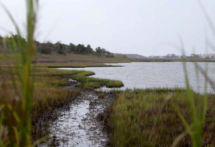
SOUTHEASTERN N.C. — A new AI model and satellite technology is in the process of reading 4,000 square miles of wetlands along the entire North Carolina coast, where the rivers meet the Atlantic Ocean. This could mean fast-tracking greenhouse gas emission reduction and further protection of the state’s coastal marshes.
READ MORE: Sledge Forest conservation plan falls through after grant application denied
ALSO: CB developer applies for permit to fill wetlands, nearby residents sound alarm
“It’s not only a more efficient, effective use of funds [compared to a years-long survey and mapping endeavor],” Jacob Boyd, salt marsh program director for the North Carolina Coastal Federation, said. “But in those areas that are disappearing quickly, implementing [a solution] the sooner the better is always the best option.”
According to analyses from the UNCW Coastal and Estuarine Studies Lab, the salt marshes, particularly in the New Brunswick area, have significantly shrunk over the years due to sea-level rise. The shoreline has shrunk by at least 11 kilometers, and has lost thousands of acres of wetlands.
A $421-million pollution reduction grant from the EPA to the Atlantic Conservation Coalition — which includes North Carolina, South Carolina, Virginia, and Maryland — is funding a partnership between the North Carolina Coastal Federation and the nature-based and sustainability tech company, Natrx. The North Carolina Coastal Federation is a nonprofit organization dedicated to environmental education, advocacy, and restoration of the state’s coastal habitats.
Since 2021, Natrx has been working on an AI model that uses satellite imagery and a high-resolution geographic information system to create a map of the salt marshes along the coast. Having a higher resolution image allows for a more precise estimate of the erosion.
Natrx’s AI model takes satellite imagery from the last 15 years — publicly and privately uploaded — to assess how the wetlands have eroded and identify the patterns within that information. While Natrx does not take its own images, the AI tool is able to create projections of how the wetlands and marshes will continue to erode, based on how already happened in the past. That information will then be used to create customized solutions for specific sites. Bald Head Island, Oak Island, and Southport all contain salt marshes and will be under observation from Natrx’s AI model and the Coastal Federation.
The analysis provided by the program will include information on natural vegetation, the salt content or salinity of the marshes, the amount of carbon within those marshes, and how much erosion the areas have undergone due to ocean waves. The information is then compiled into a dataset for the North Carolina Coastal Federation, so the organization can locate high-salinity salt marshes, or a coastal wetland, and work to maintain those environments.
As sea levels continue to rise, and the rate of their rising accelerates — 4.5 millimeter per year, up from 1993’s 2.3 mm, and continuously growing — the need for protecting salt marshes grows in significance. Rising sea levels result in faster erosion, so there is a need to collect information on marshes at most risk annually.
Currently, the Coastal Federation has to make its own projections using historical satellite images and old maps, compiled by sending people to the individual sites to collect data. Boyd said it could take “several years,” though Natrx’s new model could speed up the process. It will provide new projections within 12 months.
“So this cuts it down pretty significantly,” Boyd said — “at least half or more.”
Natrx is able to capture more information from more sources over the last 15 years, and create a projection of the rate of erosion of the shoreline in a shorter timeframe.
According to Natrx’s COO, Tad Schwendler, the Raleigh-based company began the AI project in April 2025. He said this new way helps create “large swaths” of mapping into the future, whereas before people on the ground could only capture the present day.
But this isn’t just about protecting the shorelines. It’s also about keeping harmful carbon gas out of the atmosphere.
“Salt marshes are actually one of the highest carbon-sequestering habitats in the world,” Boyd said. “It holds a lot of carbon in the soil, so when the salt marsh erodes, the carbon is released from the soil and goes into the atmosphere as a greenhouse gas.”
Greenhouse gases trap heat in the Earth’s atmosphere, which further exacerbates global warming.
When the marshes get eroded, they release the carbon that is usually kept within the soil, so having a quicker process for mapping allows the federation to address climate change sooner.
The AI mapping will help inform solutions the Coastal Federation can propose to local governments and property owners as well. Schwendler said Natrx’s datasets allow them to provide solutions on how to be cost effective, give budgetary estimates for the shoreline solutions and even design recommendations.
Natrx has a technology called “ExoForms,” individual blocks that mimic the natural landscape, and are supposed to be a better alternative to seawalls and bulkheads, hard structures that disrupt the natural flow of water. The ExoForms start off as part of Natrx’s digital designs, but Natrx has technology to essentially 3D print the blocks.
The implementation of the ExoForms is not a requirement to use Natrx’s data; however, living shorelines can also be developed based on the AI mapping, which is Coastal Federation’s preferred method. Living shorelines — such as native plants, sand, soil, and other organic materials to act as a barrier and stabilize the marsh — absorb energy from the tides that normally lends to erosion.
The federation prefers the use of living shorelines as opposed to hard structures like bulkheads and sea walls. Boyd explained maintenance of living shorelines is normally cost efficient. A living shoreline can cost thousands less than bulkheads, for example.
The Coastal Federation expects to get Natrx results by April and from there will send surveyors to at-risk, or high-salinity and high-carbon value, sites and speak to property owners the salt marshes are on. The survey will allow the Coastal Federation to figure out erosion prevention remedies and costs.
Ultimately, though, the cost of the upkeep for these living shorelines would land on the property owners where the marshes are located, whether residential or government entities. The Coastal Federation has plans to educate both, presenting solutions as need be.
“The good thing is, too, these are going to be a couple-of-year projects, so we’ll have a lot of opportunity to do outreach in the areas where we’re doing the projects,” Boyd said, “and hopefully, there’ll be some education opportunities as well.”
Have tips or suggestions for Emily Sawaked? Email [email protected]
Want to read more from PCD? Subscribe now and then sign up for our morning newsletter, Wilmington Wire, and get the headlines delivered to your inbox every morning.