


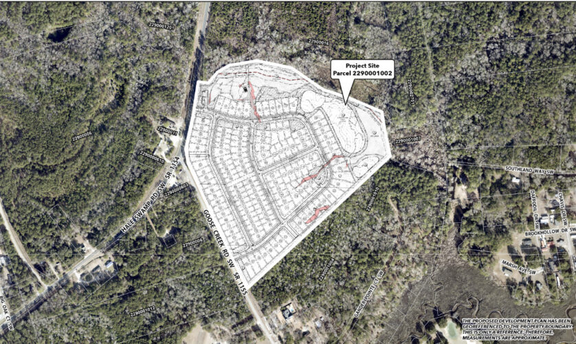
BRUNSWICK COUNTY — After the planning board in Brunswick County denied more than 1,300 homes earlier this month, it signed off on 212 to come.
Included is a 129-single-family new home development at Jinny’s Creek near Ocean Isle Beach, as well as a modification to increase the unit count for the previously approved Willow Haven development. Willow Haven, located near Bolivia, was approved last fall for 151 units, but had to complete a traffic impact analysis to get 83 more units approved for phase three.
Below is a breakdown of each.
READ MORE: Infrastructure ‘already under pressure’: 1,340 homes denied in Winnabow
Jinny’s Creek
The Brunswick County Planning Board, which gives final approval to developments unless appealed to commissioners, agreed with staff’s recommendation for Jinny’s Creek to move forward. Blue River Homes is proposing single-family homes on 37 acres at Hale Swamp Road SW and Goose Creek Road SW near Ocean Isle Beach.
An Atlanta-based company with projects in Georgia, Alabama, North and South Carolina, Blue River’s 129 units come under the current R-7500 zoning allowance of 5.8 dwelling units per acre, at 3.48. According to Paramounte Engineering’s Jim Cirello, the by-right zoning could potentially bring in 215 single-family homes.
“We’re also providing 30% of gross acreage in open space, while 20% is required,” he added, noting the team is exceeding recreational space, with 1.1 required but developers providing 1.48 acres.
A portion of the site plan creeps into the flood plain. Cirello said the site has more than 4 acres of wetlands, with a half-acre potentially impacted. Around seven lots could be impacted, to which planning director Marc Pages said the team will either need to redesign the site plan or apply for FEMA’s Conditional Letter of Map Revision, or CLOMR, to alter floodplains or base flood elevations.
Staff put a condition that a pump station will have to be constructed and elevated above the regulatory flood protection. And no dry flood proofing would be allowed.
“What’s dry flood proofing?” Cheek asked.
Floodplain administrator John Shirk explained the structure is built without flood vents, but to withstand “hydraulic forces coming into and pushing upon the structure itself.”
“It would be like having a barrel in the middle of the pond where none of the water can get into it,” he said. “We want the whole structure to be elevated.”
Two people spoke against the project, including Joe Smith Jr., who said during heavy rains and hurricanes bridges at Goose Creek Road and Hale Swamp Road wash over onto the roadways.
“These little retention ponds ain’t gonna do the trick,” he said about flooding on the development. “We have a swamp that runs through there. I know all about it. … I just feel like we need to think about all these things we’re doing. My granddaddy always told me: ‘Son, one of these days, you’re not going to know where Wilmington begins and Myrtle Beach ends.’ And he’s about right. We need to start using our heads a little bit. Our schools can’t handle it, our hospital is ridiculous. We are just not using good sense.”
Katherine Niles Norfleet grew up in the area and attended Union Elementary School, as did her children. Earlier in the meeting, Blue River’s Steven Freeman noted the technical review committee claimed the development would be districted to Jessie Mae Monroe Elementary School. Pages and Norfleet disagreed.
“I think the TRC comment is incorrect,” Pages said, noting he double checked with Union Elementary that morning.
Union is over capacity already by 50 or so students and is expected to continue to grow by almost 300 students by 2033, according to data shared by the county.
Cheek asked if the school board had considered redistricting to help alleviate the issue. Pages said discussions are ongoing though nothing has been decided.
Beyond schools, Norfleet expressed concern for flooding and increased strains on roadways, emergency vehicles, and school buses, not to mention emergency services.
“Chief Causey of Shallotte Point Fire Department already needs more staff,” she said. “Residents need to know whether current infrastructure can realistically support this growth without reducing service quality or increasing taxes.”
A traffic impact analysis indicated 1,215 vehicle trips are taken per 24-hour weekday volume.
“This development is located near roadways not near capacity,” Rynal Stevenson of DRMP, which conducted the TIA, said. “There is not a striking need for road improvements. It’s a really good area in terms of being able to handle additional traffic.”
The project passed in a 4-0 vote.
Willow Haven
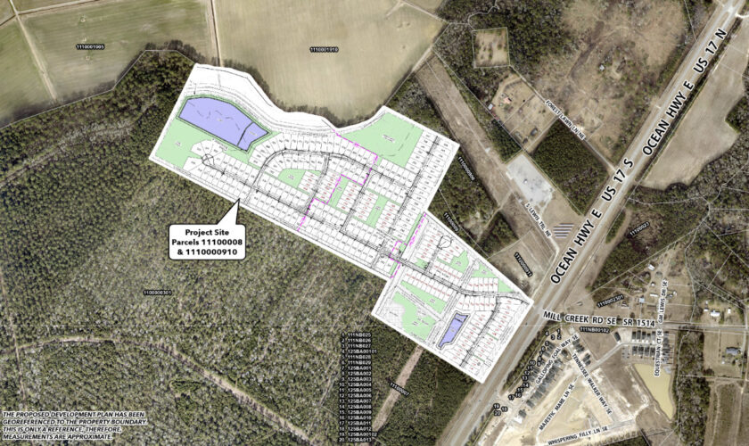
Also approved unanimously was the motion to allow an additional 83 homes to the Willow Haven planned development.
The project is proposed for Ocean Highway East near Bolivia and was approved for 151 single-family units in December 2025. This came after its 209 units were originally denied by the board in October, due to traffic and safety concerns.
Attorney Sam Franck, representing the developer, said the traffic impact analysis had to be done before the approval of the final tranche of homes in phase three.
“The third phase hit the trip generation threshold,” Franck explained, noting the developer has agreed to additional turn lanes in each direction and adding a concrete median that helps direct traffic in and out of the site.
“If we get to the level of development that the RCI [reduced conflict intersection] isn’t done, we would be required to complete it,” he added.
An RCI is planned for U.S. Highway 17 and Mill Creek Road.
Franck pointed out, overall, the development density is still lower than what’s allowed in the rural residential zoning and the commercial-low density zoning. RR welcomes 2.9 dwelling units per acre and 13.6 units per acre in CLD, though the planned development tracks 2.85 dwelling units per acre.
“The property isn’t in a flood zone but a study is being done per your code,” Franck added.
As verified by civil engineer Charles Suggs of G3 Engineering & Surveying, any lots shown in a floodplain would be required to meet compliance, via elevation or pursuing a FEMA CLOMR — or floodplain map amendment.
No one spoke publicly either for or against the development and the planning board voted unanimously to approve it.
At Port City Daily, we aim to keep locals informed on top-of-mind news facing the tri-county region. To support our work and help us reach more people in 2026, please, consider helping one of two ways: Subscribe here or make a one-time contribution here.
We appreciate your ongoing support.
