


WILMINGTON — The state transportation agency is salting the roads in preparation of any winter storm activity that could threaten the southeastern North Carolina region this weekend.
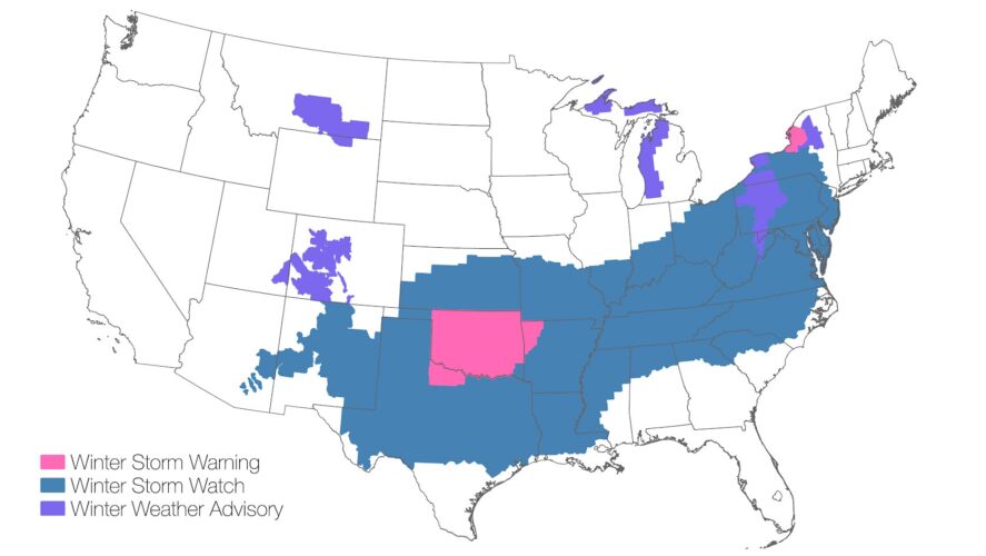
A cold system is moving across the states — spanning New Mexico to Ohio to New York, and down south from Texas to parts of Georgia and up to Virginia. According to the National Weather Service in Wilmington, 132 million people are under alerts for snow, sleet and freezing rain.
READ MORE: Attorney General warns against scam messages
While inland areas of North Carolina will see heaviest impacts, with many towns and counties west and north of the Cape Fear region already on a winter storm watch, minor disruptions are anticipated in New Hanover, Brunswick and Pender counties. Snow is less likely to reach the coast as it’s unclear how far the cold air will intrude on the tri-county region. Most accumulation is expected inland, though sleet could be problematic to roadways in town.
To prepare, the North Carolina Department of Transportation has begun salting the roads and will continue to do so, according to Division 3 Assistant Division Maintenance Engineer Jessi Leonard.
“We are preparing for the impact of ice, downed vegetation or downed power lines,” she said at a Thursday press conference.
Crews are also cutting back vegetation and checking generators and equipment.
Leonard asked drivers to be aware of NCDOT equipment on the roadways, and ensure giving the agency space and patience to treat them. Priority routes to lay the salt include major U.S. and N.C corridors, such as I-40 and 74/76.
“Those are [the] routes to the ports to get salt,” Leonard said, adding crews are preparing for several days of road treatment and are working on rotation as needed.
Though light rain is expected Friday, winter weather could arrive Saturday night into Sunday morning — 10 p.m. to 1 a.m. — as temps reach the 30s for the low. Icy spots may be possible Monday due to refreezing, depending on the extent of accumulation.
The National Weather Service has reported it’s unclear currently how much freezing rain or sleet can be expected locally. WECT also reported the American and Euro Global Forecast System models differ, with the former showing 0.22 inches of accumulation and the Euro GFS being more favorable for the region, only tracking 0.01 inches.
NCDOT engineer Leonard sent a forewarning to motorists, once precipitation begins: “If the weather is here and causing issues with the roads, try to not venture out.”
The last winter weather event Wilmington experienced was exactly a year ago, as 2 to 5 inches of snow blanketed the region. It didn’t melt quickly due to freezing temps re-icing roads overnight; this culminated in at least two snow days for area school children.
No closures of schools have been announced ahead of the current winter system, though Port City Daily will continue to track any, so readers should check back.
To prepare for the potential impacts of a winter system, officials suggest:
- Restock emergency kit with seven-day supply of non-perishable food, gallon of water per person per day and ensure medications are stocked
- Stock up on rock salt or more environmentally safe products to melt ice on walkways — sand, shovels, etc.
- Have plenty of heating fuel and store a good supply of dry, seasoned wood for fireplace or wood-burning stove — do not use oven, camp stove, or charcoal grill indoors as heating source
- Have enough clothing and blankets for warmth
- Make family communication plan
- Weatherize home as need be, such as ensuring pipes are protected to prevent freezing (wrap with insulation, run a drip, open all cabinets to circulate air, access water main shutoff in case of pipe burst, disconnect hoses from outdoor spigots)
- Bring in pets and have enough food and meds for them for up to a week
- Charge all electronics fully and have battery-operated lanterns or other light sources, as well as battery-operated radio handy if power goes
- Fill every vehicle’s gas tank and make sure brakes, tires and other car functions are properly working
At Port City Daily, we aim to keep locals informed on top-of-mind news facing the tri-county region. To support our work and help us reach more people in 2026, please, consider helping one of two ways: Subscribe here or make a one-time contribution here.
We appreciate your ongoing support.
