


BRUNSWICK COUNTY — The planning team in Brunswick County will discuss a handful of rezonings, a vested rights extension, and a few modifications to already approved developments at its mid-April meeting. Also on the agenda are new residential units proposed for the area.
Meeting on Monday, April 13, the Brunswick County Planning Board makes final decisions on projects that move forward in the state’s fastest-growing county. The Brunswick commissioners have a say only if a development is appealed.
The public is welcome to speak at planning board meetings and will receive 3 minutes to share feedback and concerns with the board.
Below is everything readers should know about the projects presented next week — the docket includes roughly 1,500 units proposed for the area.
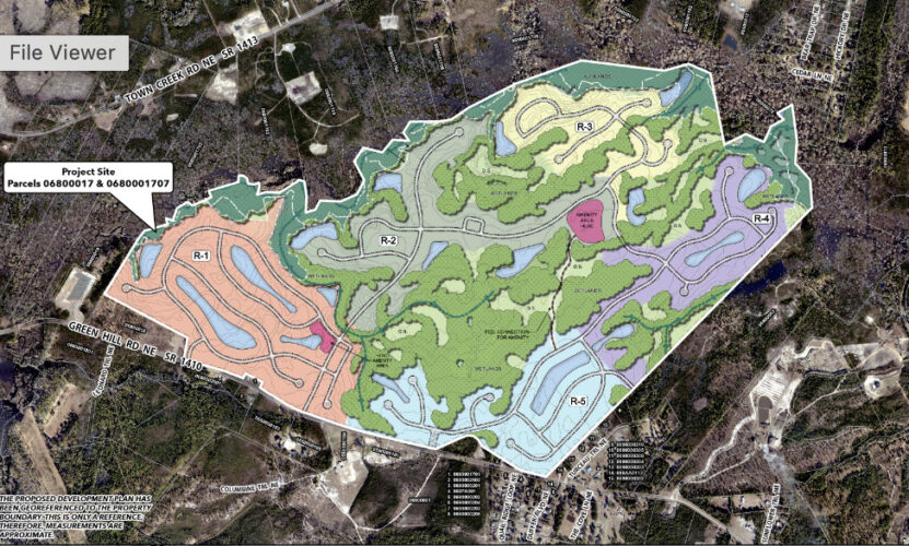
Green Hill Planned Development
Development location/background: Green Hill Planned Development is planned for Green Hill Road (SR 1410) near Winnabow. The project was denied last fall but is coming back amended and has been continued since early 2026.
Property owner: Timbervest Holdings LLC and The Reserve at Town Creek LLC
Applicant: CLD Engineering
Acreage: 784.59 acres
Units: 1,340 single family units, a decrease from the former denied plan of 1,450
Zoning: Rural Residential Density Maximum and surrounded by RR zoning, featuring single family residential, agricultural, and vacant land. It’s located a half-mile from a Voluntary Agricultural District (VAD) parcel.
Density: Allowed are 2.9 dwelling units per acre though the planned development comes under at 1.71 dwelling units per acre
Workforce/affordable housing: No
Traffic impact: 11,814 vehicle trips per 24-hour weekday volume. Roadway construction plans include reduced conflict intersections, signals, additional turn and thru lanes, additional U-turns and more on the U.S. Highway 17 (Ocean Highway), Green Hill Road NE and Cherrytree Road NE, and Rock Creek Road NE and Town Creek Road NE.
Buffers: 30-foot, 0.6 opacity peripheral buffer using existing vegetation and supplemental landscaping where necessary; 50-foot wide street buffer along Green Hill Road
Open space: 117.68 acres required, developer will provide double the amount at 310
Recreational space: 17.65 acres required and proposed
Floodplain/wetlands: Portions of the site are located in the AE flood zone, but all proposed lots will be built outside the floodplain and jurisdictional wetlands. The stormwater ponds are constructed to accommodate a 100-year flood event.
Water/Sewer: Provided by Brunswick County’s West Brunswick Sewer Treatment Plant, though approval does not constitute or guarantee the allocation of water or sewer capacity.
Unique factors: A Threatened and Endangered Species Report and a Cultural and Historic Resources Report have been conducted.
The Threatened and Endangered Species Report determines if protected animals are on site and will be impacted. It found little to no impact to potentially six of federally listed species — the Northern Long-eared Bat, tricolored bat, the red-cockaded woodpecker, the monarch butterfly, Cooley’s meadowrue, and rough-leaved loosestrife. The report looked for nesting habitats and determined there were no roost, hollowed or cavity trees to attract the animals, nor did teams spot them while surveying the land.
The Historic Resources Report also did not find known structures or sites eligible for historic or cultural preservation or any structures listed as a historic or cultural preservation resource.
Jinny’s Creek Planned Development
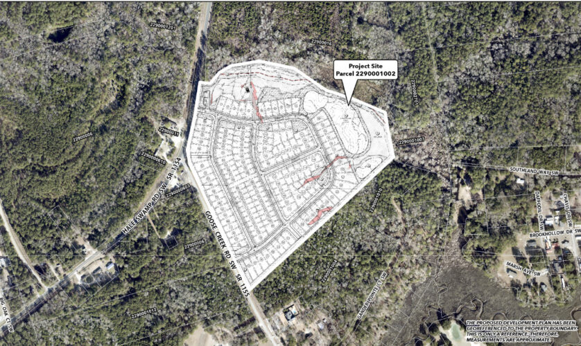
Development location/background: Jinny’s Creek Planned Development, consisting of 129 single-family lots, is planned for Hale Swamp Road SW and Goose Creek Road SW near Ocean Isle Beach. This parcel is the site of the previously approved Glen Kirk Major Subdivision, 86 single family lots. The project was approved in January 2007 but expired in January 2010.
Developers: Blue River Development Acquisitions, LLC, an Atlanta-based company with projects in Georgia, Alabama, North and South Carolina
Acreage: 37.03 acres
Units: 129 single-family lots
Zoning: R-7500 Medium Density Residential, also surrounded by the same zoning, and within a half mile of a Voluntary Agricultural District
Density: Allowed are 5.8 dwelling units per acre though the planned development comes under at 3.48 dwelling units per acre
Workforce/affordable housing: No
Traffic impact: 1,215 vehicle trips per 24-hour weekday volume. A driveway permit from NCDOT will be required prior to the recording of the individual lots. There are no road capacity deficiencies for Hale Swamp or Goose Creek Roads.
Buffers: A street buffer of 25 feet installed along Hale Swamp and Goose Creek Road. Also, there will be a 30-foot, 0.6 opacity peripheral buffer using existing vegetation and supplemental landscaping will be installed where necessary.
Open space: 7.4 acres required, developer will provide 9.49
Recreational space: 1.1 acres required and 1.48 proposed
Floodplain/wetlands: Portions of the northern side of the project site are located in a Flood Hazard Zone.
Water/sewer: Provided by Brunswick County; though approval does not constitute or guarantee the allocation of water or sewer capacity.
Willow Haven Planned Development:
Modification to increase units
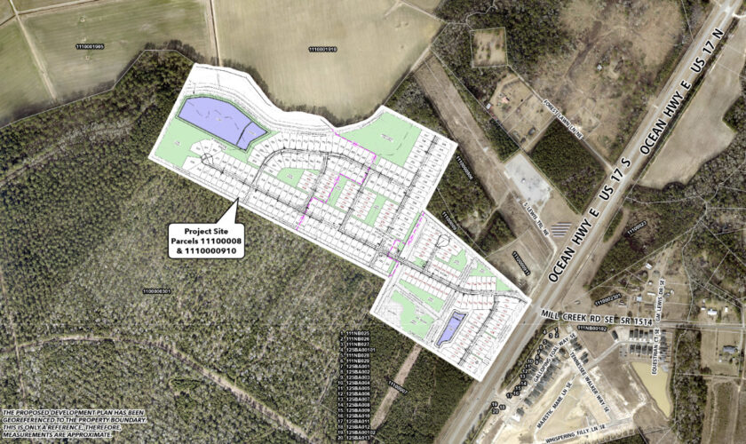
Development location/background: Willow Haven Planned Development is proposed for Ocean Highway East near Bolivia and was approved for 151 single-family units in December 2025. This came after its 209 units were originally denied by the board in October, due to traffic and safety concerns. The development returns before the planning board April 13 and is requesting 83 more units than the initial ask.
Applicant: GE Engineering & Surveying
Property owner: Franklin E. Galloway
Zoning: Rural Residential and Commercial Low Density, also surrounded by the same zoning and R-7500, featuring a majority of single family residential, agricultural and vacant land uses. It’s also located within a half-mile of a Voluntary Agricultural District.
Acreage: 81.87 acres
Units: 234 single-family units; already approved for 151.
Density: Allowed are 2.9 dwelling units per acre in RR and 13.6 units per acre in CLD, though the planned development comes under at 2.85 dwelling units per acre — which is more than the 1.84 per acre approved last December.
Workforce/Affordable Housing: No
Traffic Impact: 2,204 vehicle trips per 24-hour weekday volume, with proposed road improvements including reduced conflict intersection at US 17 and Mill Creek Road and new southbound right turn lane with 100 feet of storage.
Buffers: A street buffer of 50 feet is planned along Ocean Isle Beach Road. Also, there will be a 30-foot, 0.6 opacity peripheral buffer and a 50-foot, 0.6 opacity street buffer adjacent to Ocean Hwy East, using existing vegetation. Supplemental landscaping will be installed where necessary.
Open space: 16.37 acres required, developer will provide 16.59 with majority outside of wetlands.
Recreational space: 2.46 acres required and 3.89 proposed
Floodplain/wetlands: The site has some acreage in the AE flood zone, though no lots will be built in the floodplain or on the jurisdictional wetlands. The developer has indicated on the site plan, “A Flood Study shall be required to be completed, submitted and approved by NCFlood/FEMA prior to construction permit issuance.”
Water/Sewer: Provided by Brunswick County; though approval does not constitute or guarantee the allocation of water or sewer capacity.
Remuda Planned Development:
Modification to reduce units
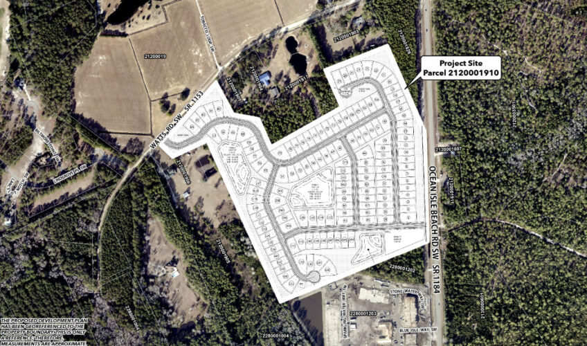
Development location: Remuda Planned Development, off Ocean Isle Beach Road SW (SR 1184) near Ocean Isle Beach, was approved in March 2025 but is requesting a reduction of 15 units and a switch to single-family only.
Property owner: Remuda Run Investments
Developers: DRB Group, with homes in Myrtle Beach, Charlotte, Sanford and Angier
Zoning: R-7500 Medium Density Residential, also surrounded by the same zoning, featuring a majority of single family residential and vacant land uses
Acreage: 45.02 acres
Units: Approved for 155 in total, to bring 60 single-family units and 95 townhomes, but wants to decrease to 140 single-family units only
Density: Allowed are 5.8 dwelling units per acre though the planned development comes under at 3.11 dwelling units per acre — less than the 3.44 planned before.
Workforce/Affordable Housing: No
Traffic Impact: 1,318 vehicle trips per 24-hour weekday volume. A driveway permit from NCDOT will be required prior to the recording of the individual lots. There are no road capacity deficiencies for Ocean Isle Beach Road.
Buffers and Surrounding Properties: A street buffer of 50 feet shall be installed along Ocean Isle Beach Road. Also, there will be a 30-foot, 0.6 opacity peripheral buffer using existing vegetation and supplemental landscaping will be installed where necessary.
Open space: 9 acres required, developer will provide 12.44
Recreational space: 1.3 acres required and 1.38 proposed
Floodplain/wetlands: The site is not located in a Flood Hazard Zone and stormwater ponds will be built to 100-year event.
Water/Sewer: Provided by Brunswick County; though approval does not constitute or guarantee the allocation of water or sewer capacity.
At Port City Daily, we aim to keep locals informed on top-of-mind news facing the tri-county region. To support our work and help us reach more people in 2026, please, consider helping one of two ways: Subscribe here or make a one-time contribution here.
We appreciate your ongoing support.
