
BRUNSWICK COUNTY — The planning board in neighboring Brunswick County will take up multiple projects Monday.
Around 600 units — a mixture of single-family homes and townhomes — are being proposed from Holden Beach to Ocean Isle, Bolivia to Supply.
Another 2,500 units, already approved in September, are requesting to modify unit types for Timber Farms and adjust for a gated entrance to a senior community. Though the plan doesn’t include reduction of footprint, the group wants, for example, to switch 200 townhomes to 168, and rather than build 1,700 single-family homes, increase that to 1,708.
Here is a breakdown of developments to be heard by the planning board Monday (check back for updates on whether the projects were given the go-ahead):
REMUDA RUN
Proposing 60 single-family homes and 95 townhomes at Ocean Isle Beach Road southwest and Watts Road southwest in Ocean Isle Beach.
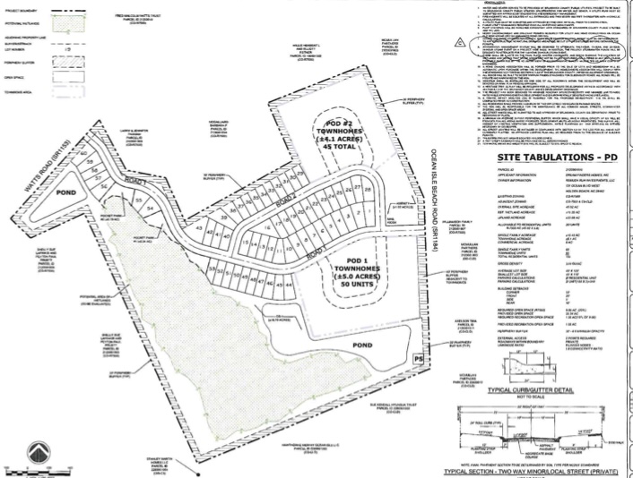
Applicant: Dream Finders Homes — a nationwide home builder company based in Jacksonville, Florida, also behind developments in Brunswick County such as Country Walk, The Groves at Olde Georgetowne, and Calabash Station.
Project/Zoning: Under R-7500 — medium density residential. — the developer is planning to build on 45 acres, accounting for 3.4 dwelling units per acre. It’s surrounded by medium and maximum (up to 5.8 dwellings per unit) R-7500 zoning districts, consisting of single-family homes and vacant land.
The developer plans for 20.34 acres of open space, though 9 acres are required for the project. Around 1.55 acres is for recreation, also above the 1.35 requirement from the county. There will be a 30-foot, 0.6-capacity buffer and supplemental landscaping as necessary. There also will be a 30-to-40-foot buffer required along Ocean Isle Road and sidewalks to be built on one side of the road throughout the development.
Traffic: The project anticipates 1,125 trips per 24-hours for weekday volume. A traffic impact analysis is required to be completed and approved by the North Carolina Department of Transportation before construction begins. There are no road capacity deficiencies apparent on Ocean Isle Beach Road. A driveway permit will also need to be retrieved from the state agency; there will be two driveways planned per unit.
Stormwater/Flood Zone: Ponds are to be constructed to meet a 100-year storm event and the project will connect to public utilities for sewer and water. No lots are located on wetlands, nor is the site in a flood hazard zone.
Staff Recommendation: Approve.
REAL GREEN (previously Magnolia Farms)
Proposing 258 single-family units at Russtown Road southwest near Ash, with expected build-out in 2027.
Applicant: Lennar Carolinas out of Myrtle Beach builds homes in both North and South Carolina. They have projects completed in Brunswick Plantation, Sunfish Cove, and Fox Hollow in Brunswick County.
Project/Zoning: Rural Residential zoning allows a max of 2.9 units per acre; Real Green is surrounded by other RR and R-7500 zoned areas as well as open space conservation zoning and vacant land. The project is scaled for 81.2 acres and is asking for 3.18 dwelling units per acre, with a 50-foot, 0.6-opacity buffer along Russtown Road. There will be 4.1 acres of recreational space, over the required 1.8 acres, and open space also triples from what’s required: 36.2 acres instead of 12.2. A 75-foot vegetation buffer is required facing any voluntary agriculture district property.
Traffic: The project anticipates 2,413 trips per 24-hours for weekday volume; a traffic impact analysis determined it would bring 176 estimated peak AM trips and 242 estimated peak PM trips. The TIA found the project would bring minimal impact to the roadway networks and didn’t suggest improvements, as Two-land Russtown Road currently has less than 4,000 annual average daily trips. The TIA, conducted by Davenport, states it isn’t expected to exceed that county by 2027 unless other developments are approved and built nearby.
Real Green will be accessible from two points onto Russtown Road, 550 feet apart. Planning staff have recommended road-calming measures for the entry into the development and that turn-arounds are installed at dead-end roads exceeding 150 feet.
Offstreet parking is required with two driveways per lot; a permit will need to be pulled from the NCDOT on this. There are no road capacity deficiencies noted on Russtown Road and there will be sidewalks on one side of the road throughout the development.
Stormwater/Flood Zone: Ponds are to be constructed to a 100-year storm event. A portion of the site is located on a flood hazard zone but lots won’t be constructed on it. There is a minimum 25-foot setback.
Staff Recommendation: Approve.
DOWDY TRACT
Proposing 46 single-family units on 17.7 acres in Bolivia.
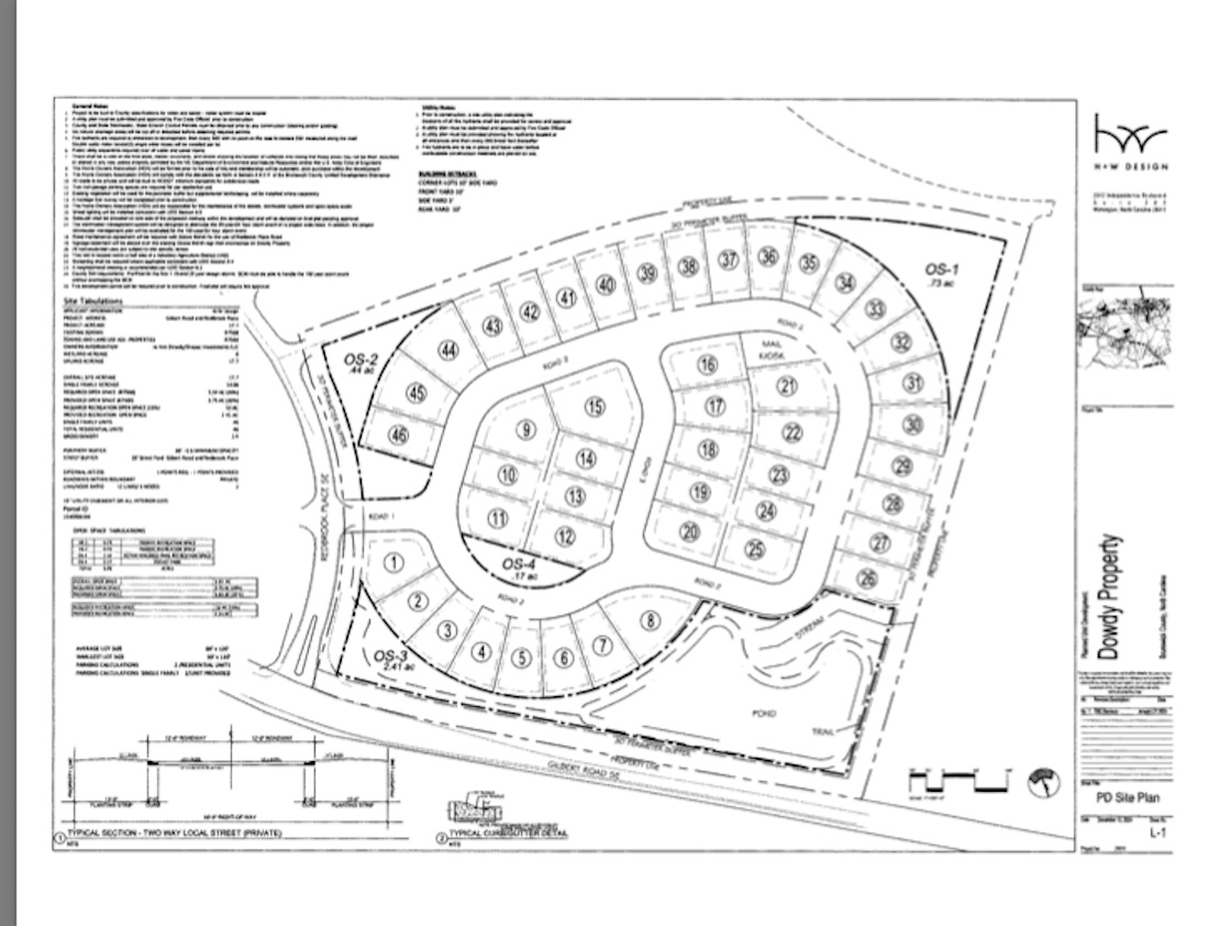
Applicant: H+W Design PLLC — a Wilmington design firm behind another Brunswick County development, Timber Farms — wants to develop almost 18 acres at Gilbert Road southeast and Redbook Place southeast.
Project/Zoning: The project is zoned R-7500 and is surrounded by the same medium density residential zoning, with single-family homes and vacant land. The group wants to build 2.6 dwelling units per acre; the maximum allowance under R-7500 is 5.6 units per acre. Lot sizes are planned for 50-feet-by-120 feet (the smallest by 110 feet).
It’s located within a half mile of the Voluntary Agriculture District. There will be a 30-foot, 0.6-opacity peripheral buffer with existing vegetation, supplemented as necessary, as well as a 30-foot buffer along Gilbert Road and Redbrook Place.
H+W will leave 3.75 acres of open space, required to be 3.54 by county standards. Recreation space will make up 2.41 acres. of which only 0.53 is required.
Traffic: An estimated 440 trips are expected per 24-hour weekday volume.
Parking will be off-street with two driveway spaces per lot included in designs. NCDOT requires a driveway permit and no road capacity deficiencies are noted for Gilbert Road. Planning has asked for the developers to secure a road maintenance agreement with Goose Marsh Planned Development for the use of Redbrook Place.
Stormwater/Flood Zone: Stormwater ponds are to be constructed to a 100-year storm event and no portion is located in a flood zone.
Staff Recommendation: Approve.
SMITH TRACT
Proposing 137 single-family units on 56.76 acres in Supply, to be built out by 2029.
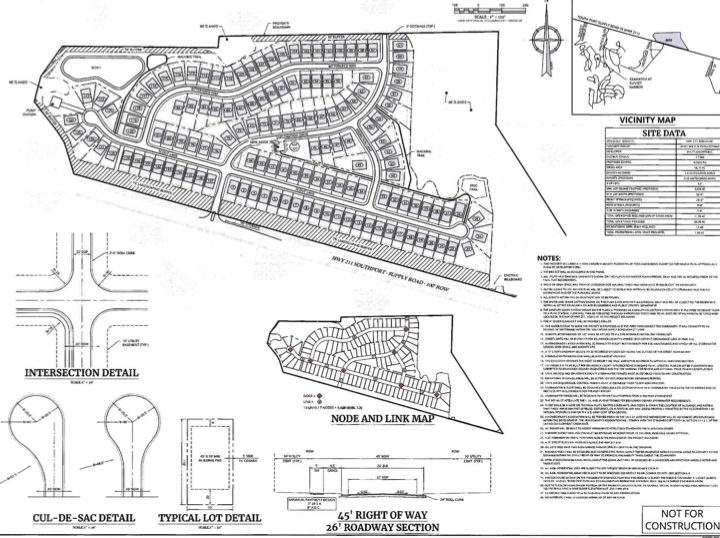
Applicant: Andy Mills of Colliers Engineering and Design is listed as the applicant for the Smith Tract, owned by James and Paula Smith. It’s located on Southport-Supply Road.
Project/Zoning: The project is in the R-7500 (with max 5.8 dwelling units per acre) and commercial low density (with max 13.6 dwelling unit per acre) districts and is also surrounded by rural residential and Oak Island jurisdiction. The site is proposing 2.41 dwelling units per acre, with 25.4 acres of open space (11.35 acres is required) and 1.86 acres of open space, slightly more than 1.7 required.
There will be a 30-foot, 0.6 opacity peripheral buffer with existing landscaping, supplemented as needed. A 75-foot buffer along Southport-Supply Road will need to accommodate the widening of North Carolina Highway 211 currently underway.
A heritage tree survey has to be completed ahead of construction.
Traffic: Trips generated in a 24-hour weekday volume are anticipated to be 1,311. A driveway permit and driveway warrant analysis is required of NCDOT before lots are recorded, with planned two spaces per lot.
Stormwater/Flood Zone: Stormwater ponds are to be constructed to a 100-year storm event and no portion is located in a flood hazard zone. However, a border of the property is close to wetlands and floodplain administrator James Pagglioli notes lots 103 through 116 on the site plan have a first-floor elevation no less than 43.4 feet.
Staff Recommendation: Approve.
TIMBER FARMS
Proposing 2,500 units on 849.97 acres near Ocean Isle. Already approved last fall but now asking to change the amounts of each unit type.
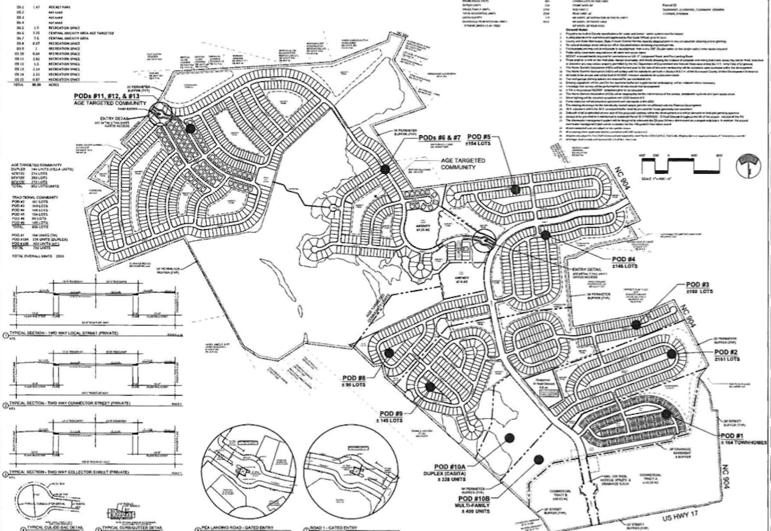
Applicant: H+W Design and Cape Fear Engineering is working on Timber Farms, approved in September 2024 to bring 2,500 units to Brunswick County. It will be located off Ocean Highway 17, a few miles north of Sandpiper Bay Club.
Project/Zoning: The project is in the zoning district of R-7500 (medium density) and commercial low density and is surrounded by the like, with also rural residential to the north. Single-family residences, commercial property and vacant land surrounds the project, which is allowed to develop at 2.94 dwelling units per acre. This will not change with the modified request of units varying.
Originally, Timber Farms’ 2,500 build-out included 1,700 single family units, 300 townhomes, and 500 multi-family units. Now, it’s asking to change the site plan to 1,708 single family units, 228 duplexes, 164 townhomes and 400 multi-family units.
It’s also asking to modify the place to include gated connectivity at the northwestern portion of the project for an age-targeted community.
There is 61.3 acres of recreation space, more than double the requirement of 25.4 acres. The project also exceeds open space which 169.9 acres escalates to 231.2 acres under Timber Farms’s plan.
Traffic: Traffic for 2,500 units has been assessed to bring in 21,317 vehicle trips in 24 hours of weekday volume, with a traffic impact analysis completed and approved by NCDOT. Parking will include two driveway spaces per lot. As well, the developer proposed an additional 250 parking spaces over what’s minimally required in the multi-family areas.
Planning recommends having limited individual driveways on the main spine road to help improve traffic flow.
The project meets the minimum vehicular access point requirements; however, staff suggests the gate design at Pea Landing account for auto stall depth and the intersection at the gate be further away to appropriately accommodate vehicles coming and going.
Staff also asked if the TIA needed to be modified due to a proposed gated spine road.
Stormwater/Flood Zone: Original master plan was approved by the floodplain administrator in 2021 but since an advisory flood map from NC Emergency Management shows some parts now fall in special flood hazard areas. Planning recommends all wetlands be placed in a conservation easement.
Staff Recommendation: Against, due to the modification of gating the spine road to Pea Landing Road, which in turn would limit connectivity in the area. A school is located on Pea Landing Road and a commercial area is coming in front of Timber Farms. Staff suggests gating side streets off the spine road instead.
Have tips or comments? Email [email protected]
Want to read more from PCD? Subscribe now and then sign up for our newsletter, Wilmington Wire, and get the headlines delivered to your inbox every morning.