


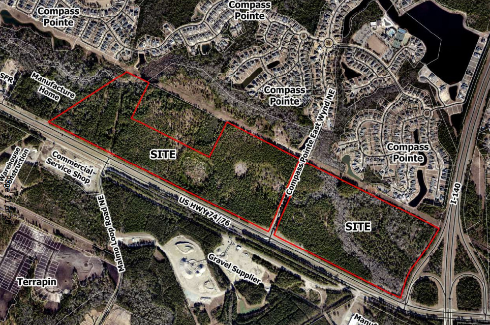
LELAND — Residents of the Compass Pointe neighborhood, directly adjacent to two Brunswick County parcels proposed for annexation, filled the Leland Town Hall chambers Tuesday night to voice concerns about the property’s zoning.
Almost two dozen commenters expressed worry over emergency access, the environment, and neighborhood character a new development could bring to the area.
READ MORE: Peacocks out, livestock restricted in Leland, following resident complaints
ALSO: Leland councilmember pushes back after probe finds policy violation, no legal wrongdoing
Developer Nathan Sanders, representing WGTRACT6 LLC and WGTRACT10B LLC — the entities associated with the two parcels — and owner of Sanco Builders wants to annex 150 acres along U.S. Highway 74/76 for a mixed-use neighborhood featuring up to 1,300 apartments and more than 23 acres of retail space. The site is mostly forested and undeveloped, located directly adjacent to Compass Pointe.
Sanders submitted to Leland a request to annex two parcels from the county’s purview into town limits. But zoning must be addressed by the planning board first. The board does not approve annexation; Leland Town Council gives final approval of both.
The two parcels in question are zoned currently under Brunswick County commercial low density (CLD) but need to be assigned Leland zoning districts — multi-family residential (M-F), general commercial (C-1), commercial trucking (C-3), and conservation (CD) — in order to be annexed into the town. Multi-family zoning allows a maximum of 16 units per acre to be built.
It was the second time the zoning request appeared before the Leland Planning Board, which initially considered the item at its Feb. 24 meeting. However, the board unanimously tabled the request to allow for revisions addressing public concerns about environmental protections and inconsistency with the Leland 2045 Future Land Use Plan.
Last month, residents expressed issues with potential wildlife harm and flooding regarding nearby Alligator Branch — a creek running through the parcels. The development will be built around the creek and wetlands, though primarily on drier uplands. Residents highlighted the removal of tree cover and adding impervious surfaces like asphalt and rooftops, could accelerate stormwater runoff and overwhelm the creek.
The public had issues with access from Highway 74/76 through Compass Pointe, preserving functionality for both existing homeowners and future development.
The first site plan included about 10 acres of open space around the creek, but once it returned Tuesday, the developer increased the protected area to 14 acres and formally designated the space around Alligator Branch as a Conservation District. This permanently protects the waterway under the town’s purview.
“I did see progress made based on comments made by this board and by the public with respect to providing certain conservation areas within that zoning district,” board member Stephen Whitney said. “It may not have been enough, but it shows a willingness to go that extra step to try to satisfy the concerns of our board and the public and I commend you on that.”
The board recommended initial zoning for the site, which includes a mix of multi-family residential zoning on 82 acres, 30 acres of C-1 general commercial and 23 acres of C-3 commercial, which allows general uses such as retail, warehousing, and service businesses. The remaining 14 acres will be set aside for conservation uses. Because this is a straight rezoning, no specific conditions for approval were included.
Traffic, access
Of all the people who spoke during public comment Tuesday, none were in support. Among the issues broached, traffic and access drew the most attention.
Under current plans, Compass Pointe’s East Wynd Road would function as a main access point for the new development. Residents highlighted the narrow, private two-lane artery serves as a primary entrance and exit for the 2,000-home Compass Pointe neighborhood already. They argued the road already handles significant daily traffic, and adding trips from the proposed development could create safety hazards and increase congestion, questioning how the road could be improved to service Compass Pointe and new residents.
“Heavy truck and retail traffic using our main entrance will slow down fire and emergency response teams for both ingress and egress when every minute and second counts,” Compass Pointe resident Christine Diehl said to the board. “Additionally, heavy truck and retail traffic will inhibit our ability to evacuate for emergency reasons. Don’t forget, we have the largest munitions facility on the East Coast and a nuclear plant less than 50 miles from where we live.”
She argued if an emergency occurred, gridlock at the neighborhood’s main entrance would make a fast evacuation extremely difficult.
Compounding the issue, residents worried about traffic impacts of potential commercial property near the East Wynd entrance, including uses such as a gas station or grocery store. Such businesses would draw heavy trucks, delivery vehicles, and additional traffic onto the Highway 74/76 corridor currently dominated by residential travel.
Nearby developments already contributing significant traffic include the 950-acre Terrapin community, with more than 2,600 homes and commercial space, and East Lake, a 2,100-acre mixed-use project with nearly 4,900 homes and 23 acres of commercial space. According to North Carolina Department of Transportation traffic maps, about 34,000 cars travel Highway 74/76 daily.
NCDOT currently grades Highway 74/76 at a Level of Service D, a rating on a scale from A (free-flowing) to F (heavily congested). While planners consider a “D” grade stable, it represents a corridor nearing functional capacity.
In response, the developer’s attorney, Sam Franck, noted East Wynd is a private road and any improvements or modifications would need to be negotiated among the road’s owners, easement holders, town staff, and the developer.
“That easement was established in anticipation that this land would be developed,” Franck stated. “It also contemplates the possibility of not only connections to East Wynd, but improvements within East Wynd.”
A traffic impact analysis is currently underway for the project and will denote roadway upgrades to be made at the developer’s expense.
Whitney and fellow member Robert Lazaro Jr. suggested the developer maintain the character of East Wynd Road and take resident concerns regarding access points into consideration.
Environmental
Residents again flagged environmental concerns, echoed from last month — notably about Alligator Branch creek. Running through the subject parcels, the public warned wetlands, wildlife habitats, and natural drainage could be disrupted by construction. Many wanted to see the areas preserved, not only critical for wildlife but for maintaining the rural, natural character that drew them to Compass Pointe.
Resident Mary Farrell, whose property directly abuts the proposed development, said she was attracted to the wooded areas and gated security system; however, the addition of multi-family housing could compromise a sense of privacy, she added. Under town code, the proposed multi-family district requires a 30-foot setback from the property line.
“I feel this is stripping me of the security that was being authored by Compass Pointe, by taking my property and making it exposed in the back,” Farrell said, suggesting a fence be installed along the Compass Pointe boundary.
Resident Patricia Matarazzo specifically addressed wildlife, stating the wooded areas could provide habitat for federally protected bird species, including the red-cockaded woodpecker. She also didn’t want to see the development impact animal activity and bird nesting in the corridor.
Franck explained that since the Feb. 24 meeting, the development team worked with planning staff to establish a dedicated Conservation District for Alligator Branch and incorporated it into the revised plan. Residents applauded the addition of the district, which protects roughly 14 acres along the stream and surrounding vegetation. Still, some didn’t believe measures went far enough.
“This little green strip, 50-to-60 feet wide for Alligator Branch: What are you gonna do — play hopscotch over this little green space? It doesn’t make any sense,” resident Richard Rooter asked the board.
Compass Pointe homeowners queried whether the site was in conflict with the Leland 2045 Future Land Use Plan. The future land use map, adopted by Leland Town Council in 2021, designates much of the site for low-density residential and a smaller portion near Alligator Branch for conservation. The 2045 plan aims to preserve open space, protect waterways, and maintain the rural character of the area surrounding Compass Pointe.
Planning staff explained the board considers the future land use plan when making recommendations, though it serves as a guide only, not a strict requirement.
Annexation
During deliberations, board members acknowledged strong public opposition but ultimately recommended approval of the zoning. Annexation into Leland would allow the town some level of oversight over how the development takes shape, which heavily influenced the planning board’s recommendation. Several members, as well as Franck, emphasized the parcels could be built out under Brunswick County rules regardless of annexation.
Apartments and large-scale commercial uses, including big-box retail and shopping centers, are already permitted under county zoning, meaning a project of similar or even greater intensity could move forward outside of Leland’s jurisdiction.
“This is not about something versus nothing,” planning board member Cody Watkins said. “If it develops under the county rules or under the town rules — that’s really what we’re looking at.”
Franck said the developer is seeking annexation in part because of the value of being within Leland’s municipal boundaries. He noted the property owner wants future residents to “call Leland home” and participate in the town’s services and governance, adding the benefits of being part of the town outweigh the restrictive zoning process. By entering town limits, the development gains access to municipal water and sewer via H2GO, as well as Leland police and fire protection. In exchange, the town will gain property tax revenue as commercial and residential units are constructed.
As Planning Board Chair Alan Kerry reminded the public, the town council would sign off on everything formally: “We are not here to approve a development. The board is here to approve the zoning alone, and we must take into account any and all uses applicable to that zoning.”
Planning staff emphasized details, including site access points and traffic and safety improvements, are reviewed later during the technical review committee and permitting process, bringing together varied departments including the Leland Fire, Police, and engineering departments, and state and federal agencies, like NCDOT, to sign off on it.
Leland Town Council will hold a public hearing on April 16 to consider the zoning and annexation.
Have tips or suggestions for Charlie Fossen? Email [email protected]
At Port City Daily, we aim to keep locals informed on top-of-mind news facing the tri-county region. To support our work and help us reach more people in 2026, please, consider helping one of two ways: Subscribe here or make a one-time contribution here.
We appreciate your ongoing support.
