


PENDER COUNTY — Three subdivisions are going before Pender County boards this week, and if approved, could bring 1,354 new homes to the area.
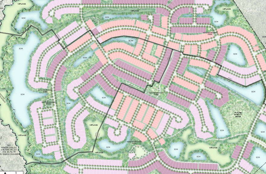
On Tuesday, the Pender County Planning Board will hear a rezoning request and hold a public hearing for a 930-unit single-home community for ages 55 and older, located north of Sidbury Road.
Then on Thursday, the technical review committee will consider three projects: a 334-unit single-family development with 2 acres of commercial space, a 90-unit single-family-home development in Topsail Township and an 11.15-acre operation expansion for a sand-mining operation.
READ MORE: 1K Rocky Point development rejected, wastewater plant moves forward
Here is a breakdown of the projects:
Sidbury Development
Property owner/developers: Adam Sosne, CEO of McAdams Homes with Sidbury Development I, LLC, owns the property. Sosne has been a prominent figure in the Cape Fear since he told Wilmington Business Journal in 2021 he planned to build 5,000 homes in the area within the next decade.
In 2023, McAdams Homes began a 400-unit development, Point South in Scotts Hill with single- and double-family homes, as well as 20 acres for commercial development.
Zoning: Currently zoned as Planned Development, which allows for flexible mixed-use development and design.
Units/density: The Sidbury development will include 334 single-family detached home lots and a reserved 2-acre area for future commercial development. It is not yet determined what businesses the development will include. The developers also propose the possibility of a clubhouse, covered bus stop and mail kiosk.
Density for the site is 2.57 lots per acre. Under planned development zoning density allowance is based on the Imagine Pender 2050 Future Land Use plan. Under Imagine Pender, the development is classified as a residential neighborhood, allowing 3 to 6 units per acre.
Acreage: The development is on a total of 130.06 acres, with the developer estimated approximately 85 acres constructed upon.
Open space: 10.02 acres of open space are required per Pender County’s Unified Development Ordinance — which comes out to 0.03 acres per lot. However, developers are providing 58.8 acres of open space — or approximately 0.18 acres per lot.
6.5 acres will be active open space and may be used for dog parks, playgrounds, a picnic and grill area, and a mail kiosk.
Traffic impact: The official North Carolina Department of Transportation traffic analysis is still ongoing. However, based on the Institute of Transportation Engineers Trip Generation Manual there would be approximately 3,090 trips per day. There are 240 trips during the peak am hour and 305 trips during the peak pm hour.
Possible ways to mitigate traffic caused by the development are turn lanes along Sidbury Road. The plans also highlight one primary connection to Sidbury Road rather than multiple.
Buffers/surrounding properties: The property will have 30-foot type A buffers, 20-foot type B buffers and 10-foot type C buffers. The type A and B buffers are near the front of the property. The type C buffers are along parts of the property that border undeveloped land.
Preliminary drawings do not include landscape plans for these buffers.
Wetlands: The site has 29.8 acres of wetlands, based on development plans it does appear that some units may infringe on the wetlands. Roadway networks and lots on the site are positioned around the wetlands to reduce any possible impacts.
The application does not include specific impacts on wetlands.
Floodplain: The development’s stormwater system will be designed to control peak flow of 10- and 25-year strom events by using closed pipes, curb inlets and drop inlets to move runoff. The site drains toward Island Creek into the Cape Fear River Basin.
Unique factors: The land is near a concrete plant and includes existing infrastructure, including cell tower, natural gas and drainage easements.
Dupen Tract Conditional Rezoning
Property owners/developers: Also developed by McAdams Homes, the property owners are MH Sidbury, LLC, AGSLIL, LLC, JAMLIL, LLC, and Sidbury Venture Partners, LLC
Zoning/density: The current zoning is rural agricultural to allow for a minimum of 1 acre per single family home. The applicant is asking to rezone to a conditional zoning district, which would bring it up to 2.3 dwelling units per acre. It falls in line with the Pender 2050 Future Land Use Plan which labels the property as being for residential land use, recommending a density of 3 to 6 units per acre.
The rezoning requires a planning board review, with a public hearing set for Sept. 1; the board’s recommendation will then go before the Pender County Board of Commissioners for the final determination.
Units: The applicant is proposing 930 detached single family homes. 327 homes will be on 41-foot wide lots, 331 homes will be on 51-foot wide lots and 272 homes will be on 65-foot wide lots.
All three lot sizes have a maximum building height of 35 feet.
Total acreage: 404 acres
Open space: There is a requirement of 27.9 acres, coming out to 0.03 acres per unit. The developers are proposing 68.6 acres of open space; 13.95 of these acres will be active open space and 54.65 acres will be passive open space.
Wetlands: 38.25 acres are estimated to be wetlands. 37.97 acres are jurisdictional wetlands, meaning federally protected and permitted from the U.S. Army Corps of Engineers. The site plans show all residential units are built outside of wetlands.
Floodplain: 20.6 acres are in a 100-year flood plane meaning there is a 1% chance of flooding during any given year. Housing units are located outside of the flood zone.
Traffic impact: A traffic impact analysis will be required because the project exceeds the county’s 1,000 trips per-day threshold. The development is projected to produce 3,562 trips per day with 191 during the peak morning hour and 257 during the peak evening hour.
County staff did note projected traffic is lower than what would be produced from the 930 single-family homes — normally generating 7,771 trips for a development of this caliber. However, since it’s senior adult housing, county staff estimate the development to produce under half of that. Several 55+ communities, like Leisure Villas, cite the reason for less traffic as less people per home, fewer cars and less overall traveling.
The site’s primary entrance would be from Sidbury Road. Once a TIA is approved by NCDOT, it will include recommendations for potential traffic improvements such as turn lanes at the project entrance and a traffic signal at the project entrance.
Buffers/surrounding properties: A buffer is proposed for Sidbury Road frontage, running parallel to the street. The typical standard is at least three canopy trees, two understory trees and a grass cover of at least 98% coverage per every 100 linear feet.
Buffers also will exist around property parameters, such as areas adjacent to the entrance road. The buffers’ standard minimum is a 10-foot wide strip with a 6 foot high solid fence or an evergreen hedge.
Unique factors: The development is a community for people 55 and older.
Shaw Mine
Property owner/developers: Shaw Mine, LLC owns the property and is already doing nonmetallic mining on the site. The company’s request is to expand its operations.
Zoning: The property is currently zoned as rural agricultural. No rezoning is being requested, as Shaw Mines submitted a revision for its special use permit in July to accommodate the expansion.
Acreage: The property is a 104-acre tract with the current mining area taking up 34.9 acres.
The new mining area expansion will be 11.15 acres; 7.04 of those acres will be non-excavated space for parking, storage, educational training on workforce development and heavy equipment operating training and yard waste recycling.
The remainder 4.11 acres is proposed excavated expansion of the current mining operation and mobile equipment parking
Units: No new structures are proposed as a part of the expansion.
Traffic impact: A traffic impact analysis is not required, however, based on sales record, the truck count daily average is nine.
Buffers/surrounding properties: No street buffers are listed on the application. There will be a 50-foot buffer surrounding all wetlands.
Wetlands: The application does not quantify wetlands, but a 50-foot buffer line has been surveyed and marked between the property line and wetlands. Approximately two wetlands are on the expansion site.
Floodplain: A portion of the site is in an AE flood zone, meaning there is a minimum of a 1% chance flooding happening annually with waves not exceeding 3 feet. Other portions of the expansion are in Flood Zone X (shaded), which comes with a moderate flood hazard — typically between a 100-year flood zone and 500-year flood zone.
Unique factors: The 104-acre property already has an estimated 34.9-acre existing mining area.
Riverstead Phase 1
Property Owner: 210 Timber Partners, LLC — a North Carolina limited-liability company.
Developers: Riverstead Ventures, INC — a company that has worked on many coastal homes in the tri-county region including Helms Port and Compass Pointe Golf Course.
Zoning/density: The current zoning is rural agricultural which allows for low density residential use. The projected density is 1.94 dwelling units per acre. Rural agricultural zoning allows for a density of minimum of one dwelling unit per acre.
Representative for Pender County Brandi Cobb told Port City Daily the development will not require rezoning.
Units: 90 single family units.
Acreage: 174.60 acres.
Open space: Designated open space is not required per the zoning district.
Wetlands: Wetlands are present; however the amount of wetlands and how they will be impacted are still being evaluated.
Floodplain: Parts of the development is in a floodplain where there is a 1% chance of flooding annually, leaving a moderate risk of flooding.
Traffic impact: No traffic impact analysis has been done, however if trips are expected to reach over 1,000 per day, one will be required.
Buffers/surrounding properties: No buffers are required per the zoning district.
Unique factors: According to Cobb, no permits have yet been given for this project yet.
Have tips or comments for Sophia DePhillips? Email [email protected]
At Port City Daily, we aim to keep locals informed on top-of-mind news facing the tri-county region. To support our work and help us reach more people in 2026, please, consider helping one of two ways: Subscribe here or make a one-time contribution here.
