


CASTLE HAYNE — Within 10 miles of Sledge Forest, a limestone quarry has been proposed for expansion much to the chagrin of neighbors and environmentalists. At a public hearing on July 14, speakers raised concerns about irreparable damage to the local environment.
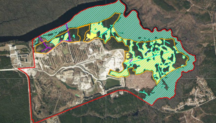
The North Carolina Department of Environmental Quality’s Division of Water Resources held the hearing Tuesday at the Heide Trask Senior High School for the proposed expansion of the Martin Marietta limestone quarry in Castle Hayne. The project proposes a 358-acre expansion of its already 1,400-acre property; with the inclusion of protected wetlands and waters, the total acreage for the extension equals more than 700 acres.
According to the Martin Marietta Materials’ permit application, the expansion is necessary to meet needs stemming from growing development in the Wilmington metropolitan area. Martin Marietta Materials is a national corporation that mines limestone to create building materials for roads, driveways and other construction projects; the quarry provides these materials to local developments. In order to continue providing the materials for construction in southeastern North Carolina, the company needs more limestone.
READ MORE: 3K acres of Sledge Forest could be preserved, contingent on Hilton Bluffs development
ALSO: Controversial development planned for Sledge Forest paused ahead of appeals hearing
Though company representatives weren’t there, the hearing was hosted by the North Carolina Department of Environmental Quality. The hour-and-a-half was dedicated to public feedback, with 17 people signed up to speak — many were representatives from local advocacy groups.
The expansion would grant an additional 26 years of limestone reserves. While Martin Marietta doesn’t explain what the current capacity of the reserves are, it notes in its application the current capacity cannot support medium and long term needs.
Mining for limestone can lead to the disturbance of sediment which could then run downstream and create cloudy drinking water, or turbidity. The mining would also result in the dewatering of wetlands, permanently destroying them.
Martin Marietta included in its application some mitigation efforts, which includes the conservation of 286.92 acres of jurisdictional, or protected, wetlands and open waters. Martin Marietta also utilized a 2:1 ratio for its mitigation, which means for every acre the company develops or digs up, the company will preserve 2 acres.
“The Army Corps mentioned a maybe 3:1 ratio,” Roger Shew, senior lecturer of geology at the University of North Carolina at Wilmington, said.
He referred to the U.S. Army Corps of Engineers’ standard for land conservation: “I’d say it’s got to be 4:1 or more.”
Further mitigation plans include stormwater management and erosion control, as well as redirecting runoff to a pit or other erosion control structure. The company will also be implementing a minimum 50-foot wooded buffer around the wetlands and open waters “not directly impacted by this requested permit.”
However, critics pointed out the company named and dismissed four alternative locations which would have less impact on the environment; most are off-site from the Castle Hayne quarry. The locations were outlined in the company’s submittals to the Division of Water Resources.
Part of the issue with the company’s preferred location is the affected wetlands would mean less filtration of sediment contaminating the local environment and drinking water.
The location environmentalists point to as having the least impact on the environment is the Rocky Point Quarry, notably because Martin Marietta already leases the property and it has been a mining site since 1983. The quarry is roughly 3.5 miles away from Castle Hayne.
Unlike the Castle Hayne site, expansion in the Rocky Point Quarry does not carry the same impact on water quality because it is not directly adjacent to major, sensitive waterways and high‑quality wetlands. Castle Hayne is close to the northeastern Cape Fear River and high-quality wetlands, containing biodiversity and clean water. The site is also located in a 100-year floodplain, adjacent to the habitats of endangered species and the Cape Fear River.
Northeast Cape Fear River is home to fish nurseries, freshwater fish and anadromous fish, which hatch in freshwater before migrating to the ocean. Fish habitats near the proposed expansion site feature endangered species like the Atlantic sturgeon and the magnificent ramshorn snail. It is also home to the bald eagle and the northern endangered long-eared bat. Endangered species of plants with habitats near the site include Cooley’s meadowrue and rough-leaved loosestrife. Only the northern long-eared bat is noted in the application as potentially being affected by the expansion.
Local environmentalists argue otherwise. Birds, they explained, often land and feed in the wetlands near the area, so they would be disturbed by the expansion. Furthermore, the area is a breeding ground for fish, which locals argued could be disturbed through the degradation of the surrounding environment.
Rocky Point Quarry, on the other hand, is not located near important fish habitats or a nationally significant floodplain.
Shew explained the Rocky Point site was the best option because there was less chance of contamination and disturbance of local wildlife.
“Even though there’s hydric soils — these wet soils — the hydric soils are not connected directly to the river,” Shew said.
According to the application documents, the quarry expansion would permanently destroy and dewater 143.46 acres of wetlands and 9.7 acres of open water. By comparison, the Rocky Point Quarry is not expected to impact any wetlands or open waters.
Alternative number two would also be configured for the Castle Hayne site but would impact 110.07 acres of wetlands and 3.35 acres of open water instead.
In the long term, Shrew noted this could result in turbid, or cloudy, waters. Chair of environmental activist group the Sierra Club, Kelly McConnell, agreed.
“Dewatering for limestone expansion decreases access to drinking water,” she explained. “When you remove water from the wetlands, groundwater flows to replace it.”
This, she said, could stir up pollutants.
Cape Fear River Watch Riverkeeper Kemp Burdette expanded on this in his comments Tuesday night.
“While the application doesn’t adequately address water quality impacts, increased turbidity, elevating chlorophyll A, a decrease in dissolved oxygen, increased heavy metals and changes in pH and temperatures seem all but certain,” he said.
School board candidate Margaret Gewirtzman brought up her daughter, Lily, to discuss potential increased water pollution and decreased water quality.
“Not to mention all the chemicals that are going to backwash into groundwater,” Gewirtzman said.
Gewirtzman worried the contamination of the groundwater would affect her daughter while she is “playing in the yard,” running through sprinklers or swimming in the neighbor’s pool.
A majority of the preferred expansion site is also within a 100-year floodplain and is designated as a special flood hazard area, which would require a FEMA permit.
Burdette explained locals can expect “double on the force of flooding for communities along the river.”
North Carolina House of Representatives candidate and current school board member Tim Merrick noted the clearing of trees presented an issue. Not only do they help regulate climate and provide heat control as McConnell explained to Port City Daily, but Merrick added trees help mitigate flooding too.
Canopy trees, which Merrick cited directly, help soak up stormwater into the soil and reduce the speed and volume of water entering streams, helping prevent flash floods.
“It’s good to maintain things like our tree canopy that will help cool the earth and help to mitigate floods from our ever-increasing storms,” he said.
Speakers at the July 14 hearing also brought up “inadequate explanations” of why the alternatives were not chosen when the potential damages were numerous. They said the scope of the damage was downplayed and the mitigation efforts lax. Dr. Robert Parr, an emergency physician with a masters in oceanography, explained the application didn’t include site-specific modelling projecting groundwater flow and the transportation of dissolved materials from the mining.
Port City Daily reached out to Martin Marietta to ask why the alternative locations were not chosen given they would mitigate more damage to the environment but did not hear a response by press. However, the application explains the Rocky Point Quarry does not have a long-term reserve capacity.
Outside of environmental concerns Merrick pointed out the impacts of the expansion on Castle Hayne residents.
“We should care very much about the residents of Castle Hayne who are experiencing over-industrialization, and they lack the traffic infrastructure to maintain more industry,” he said.
Merrick explained placing this expansion in the context of its close proximity to Sledge Forest added to the frustration of Castle Hayne residents speaking out.
Sledge Forest has been at the center of tension in New Hanover County since 2024 when developer Copper Builders announced its proposal to build Hilton Bluffs, then more than 4,000 homes on the roughly 4,000-acre land. Since, however, the development plan has shrunk to 1,800 homes on around 600 acres.
Just last month, the group announced a partnership and purchase agreement between the developer and the North Carolina Coastal Land Trust. The nonprofit has similarly protected large swathes of land in the past, like the south end of Topsail Beach, and will preserve 3,200 acres in Sledge Forest, but only if the development moves forward. It’s being challenged currently by Save Sledge Forest, represented by the Southeastern Environmental Law Center and residents from Wooden Shoe and Marathon Colony subdivisions, represented by Grady Richardson. It also has a board of adjustment hearing in July. The partnership satisfies the county’s conservation development requirements, allowing the developer to cluster 1,800 homes on uplands while the Coastal Land Trust would own and permanently preserve the remaining acreage.
Shew explained Sledge Forest is in the same wildlife corridor as the proposed site expansion for Martin Marietta.
Merrick added the combination of the increased traffic from the proposed Hilton Bluffs development and the quarry expansion would overwhelm motorists driving through Castle Hayne and residents who live there.
“Nobody wants industry in their backyard,” he said. “They’re just concerned about their quality of life and I don’t blame them.”
Community members interested in submitting comments about the quarry expansion will have the opportunity to do so until August 13 at 5 p.m. Comments can be submitted here under the project name “Castle Hayne.”
The address for mail-in comments is: Stephanie Goss, 401 Permitting, 1617 Mail Service Center, Raleigh, NC, 27699-1617.
The application and proposal documents can be found here.
[Ed. note: The article has been updated to correct quote attribution. Port City Daily regrets this error.]
Have tips or suggestions for Emily Sawaked? Email [email protected]
At Port City Daily, we aim to keep locals informed on top-of-mind news facing the tri-county region. To support our work and help us reach more people in 2026, please, consider helping one of two ways: Subscribe here or make a one-time contribution here.
We appreciate your ongoing support.
