


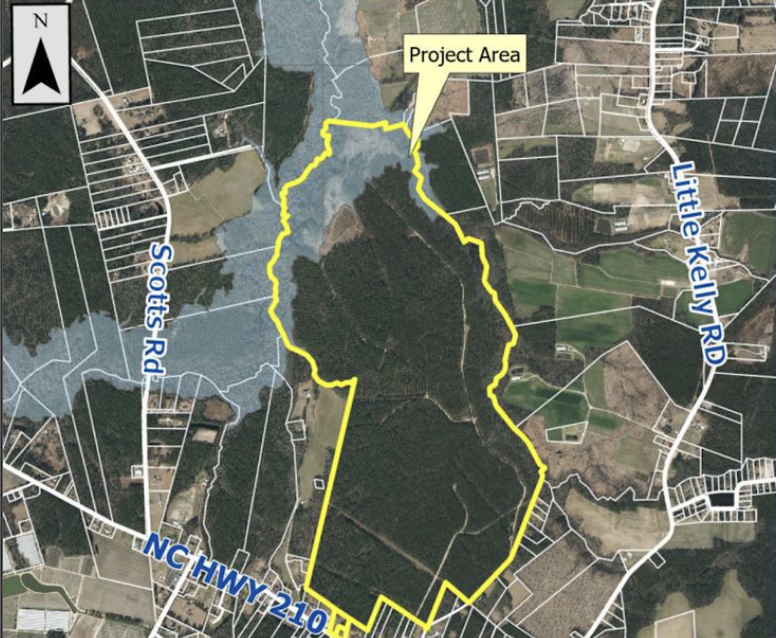
PENDER COUNTY — What’s being billed as a “conservation-forward development” will go before the Pender County Planning Board in early August. Bill Clark Homes is proposing 1,023 single-family homes on 630 acres near the intersection of N.C. Highway 210 and Pine Village Drive in Rocky Point.
Construction is expected to occur from 2028 through 2035. But to move forward on plans, the developers need a rezoning first. The land is currently in a rural agricultural district, but the applicant is requesting a conditional zoning district.
Staff recommends approval to the planning board, which will make its suggestion to commissioners, who have ultimate authority. The Pender planning staff note the project is consistent with multiple policies, including but not limited to strategically guiding locations of growth to align with infrastructure needs in the next 25 years countywide, while also protecting natural areas.
READ MORE: Pender schools to tighten spending again, after state pay raises, Title I cuts lead to $1M gap
While the acreage is expansive, a large portion of the property will remain undeveloped; staff recommends 40% be put into a conservation easement as a condition for approval. Conservation would include both uplands and floodplain areas, with the community designed around natural features.
“This project demonstrates that responsible growth and environmental stewardship can coexist,” according to the developer’s application.
Planning staff acknowledged in the application documents that a development of this size could create “growing pains,” but concluded the proposal aligns with county policies and the area’s anticipated growth.
A public input meeting was held earlier this month, with two dozen people attending at the Burgaw Community House; mailers were sent to all property owners within 500 feet of the subject parcels. Neighbors expressed concerns over losing access to a hunting club on the land, traffic growth, entrance and exit points, school capacity, flooding and more.
Residents will have another opportunity to comment during the planning board’s Tuesday, Aug. 4, meeting at the Hampstead Annex Auditorium.
Below is the breakdown of the development:
Developers: Clark Builders, LLC, also known as Bill Clark Homes, has completed residential projects in Wilmington, including Riverside Cove and Hanover Lakes. Paramount Engineering is also part of the project team.
Land owners: Weyerhauser Forest Holdings, LLC, a timber company; Lynn D. Taylor and Cherry Futreal Davis
Background: Weyerhaeuser manages the property, which consists primarily of open understory pine forest that is periodically harvested. Weyerhaeuser has a three-year timber reservation on the property and intends to cut the timber prior to construction from Bill Clark Homes.
The property is surrounded by Riley’s Creek, with its tributaries bordering approximately two-thirds of the land.
Units: 1,023 single family homes, with lot sizes around 0.1 acres — or 6,750 square feet. Setbacks are 50 feet from the lot’s front, 5 feet from the side of the home and 10 feet in the rear from the home; the maximum height is 35 feet. Development is to be clustered on the land’s already timbered areas and will be staggered for construction, including 175 units by 2028, 450 units by 2030, 775 units by 2032, and 1,023 units by 2035.
Zoning: Currently, the land is zoned rural agriculture, to serve either non-residential agricultural uses or very low-density development. It’s the county’s lowest density zoning.
The request is for a conditional zoning district, often used for higher density and mixed-use developments. It also means site plans must be shown and conditions met for initial approval; a master development plan is then put forth to work through the process administratively.
The county’s future 2050 Land Use Plan has the property marked as a rural neighborhood zone, allowing for transitions from rural to suburban densities, often used for medium density in the southern part of the county or within low-density residential developments. It’s also applicable for larger rural roads and state highways, meant to serve a community with commercial uses.
The applicant noted, since the project is located along the N.C. 210 corridor, it conforms with the county’s goal to provide development transition from rural agriculture.
Surrounding zoning: The property is also surrounded by rural agriculture, residential performance, and commercial zones, as well as vacant land. Dwelling units per acre range from 1 to 4.84, depending on the zoning.
Density breakdown: The project is proposing 1.62 dwelling units per acre, coming in under the land use plan allowance of 2 dwelling units per acre or less for rural neighborhoods, meaning the site could hold up to 1,119 units. However, it’s more than the current rural agriculture zoning, which allows 1 dwelling unit per acre.
Acreage: 630.03 in total, with 253.52 acres conserved
Wetlands/floodplain: 81.54 acres are in the 100-year floodplain, 150.5 acres are jurisdictional wetlands. The applicant has submitted a jurisdictional determination to the U.S. Army Corps of Engineers.
Acreage conservation: No homes will be built on 253.52 acres; of that, 103.02 consist of uplands and 150.5 are wetlands, inclusive of the 81.54 floodplain. Staff has requested the conserved land be put into a formal easement maintained by the homeowners association, and restricted from being developed except for passive recreation facilities, such as walking trails. The easement would not go into effect until the timber company’s three-year contract is up.
The developer plans to cluster homes on the interior of the site, so green space and additional riparian buffers around the project boundary remain natural.
Buffers: 15 feet to 30 feet, depending on whether it’s a road frontage or non-street boundary lines. Staff also requests preservation of existing vegetative buffers and supplemental planting and infrastructure, inclusive of canopy and understory trees, grass and ground cover, and wood fencing, depending on where the buffer zone is located.
Open space: 45 acres, of which 30.69 is required by the county. The development will include 31.58 of active open space, with pathways around the neighborhood and conservation areas, connecting to sidewalks for residents to walk or bike to amenities and neighborhood parks. There will be a community park along Riley’s Creek or a nature overlook with a potential canoe and kayak launch. There will be 13.38 acres of passive open space.
Traffic: The development will bring 9,318 daily vehicle trips, with 708 trips during the morning peak hour and 910 during the evening peak hour. Traffic counts on N.C. 210 average about 5,300 vehicles per day east of the site and roughly 4,600 vehicles per day between Clarks Landing Road and Pine Village Drive.
The roadway’s estimated capacity is 21,000 vehicles per day, indicating 210 can handle anticipated traffic volume increases associated with the proposed conditional zoning district.
However, a traffic impact analysis has to be completed to make those determinations and approved by the North Carolina Department of Transportation and the Wilmington Urban Area Metropolitan Planning Organization. This could come with recommendations for off-site improvements, such as including turn lanes or traffic signals at the development’s entrance.
The neighborhood will have two access points and stubouts for future connectivity. Primary access is proposed off N.C. 210, with a secondary emergency-only access provided via Cricket Drive, secured by a gate.
Water/sewer: The stormwater system will meet the 10-, 25- and 50-year events and be analyzed for a 100-year event. Stormwater discharge cannot exceed pre-development conditions by more than 10%. Public water is also available for the site and two options have been proposed for sewer service: Develop a private sewer treatment facility or build a pump station for Pender County Utilities if sewer becomes available in the area for connection.
Schools impact: The development is anticipated to bring around 400 students to area schools. Facilities impacted include: Cape Fear Elementary — enrolled at 549 with 676 capacity; Cape Fear Middle School — enrolled at 415 with 691 capacity; and Heide Trask High School — enrolled at 683, with 815 capacity.
Unique factors: The developer will place bus shelters in the neighborhood for school students, as coordinated with Pender County Schools.
According to Paramount Engineering, environmental consultants found no endangered plant or animal species on the property.
At Port City Daily, we aim to keep locals informed on top-of-mind news facing the tri-county region. To support our work and help us reach more people in 2026, please, consider helping one of two ways: Subscribe here or make a one-time contribution here.
We appreciate your ongoing support.
