
WILMINGTON — Being dubbed as one of the most rapidly intensifying storms, Hurricane Erin went from a Category 1 on Friday and within 24 hours to a Cat 5 Saturday, before decreasing to its current Cat 4 status. Though landfall isn’t expected along the Carolina coast, her aftereffects will still be felt.
The National Weather Service anticipates Hurricane Erin will bring life-threatening surf and rip currents throughout the East Coast, expected to start Tuesday and last all week.
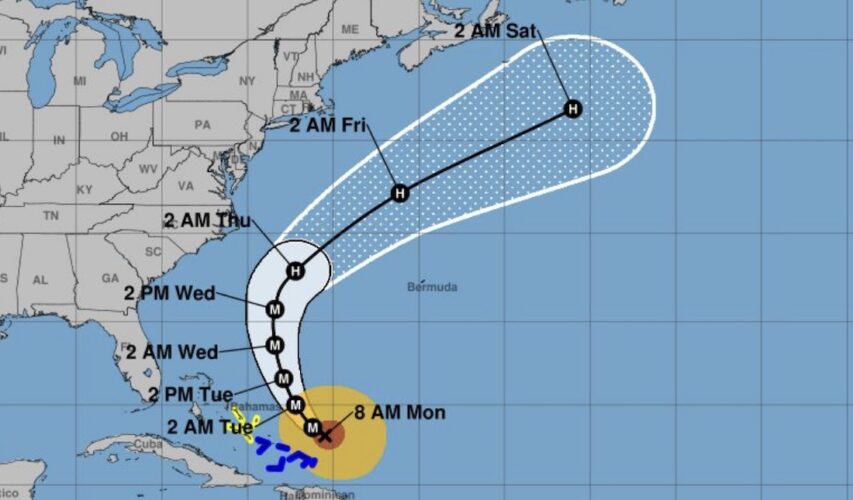
The hurricane is skirting by the Caribbean Monday as rain bands and storm surge are affecting Turks and Caicos and Bahamas, both under a tropical storm warning. Nearly 150,000 people are without power in Puerto Rico, due to the storm’s high winds.
The first hurricane in the Atlantic for the 2025 season, as of Monday morning Erin was 105 miles north-northeast of Grand Turk Island, with 130-miles-per-hour maximum sustained winds; it’s moving 13 mph. The path is projected to turn northeast and remain out to sea, running parallel to the Carolina coastline by Wednesday and Thursday.
As such, the Outer Banks is under a state of emergency and Ocracoke Island issued a mandatory evacuation. Coastal flooding could “render Highway 12 impassable,” according to Dare County officials. They anticipate dangerous waves of 20 feet or more, which could wipe out dunes protecting the area.
The local tri-county region is under a high surf and small craft advisory, with New Hanover also in a coastal flood advisory, according to NWS Wilmington. Breaking waves are expected to be 6 feet at the opening of the Cape Fear River and the Atlantic Ocean; they could grow to 10 feet north of the Cape Fear. Dangerous swimming conditions and some potential beach erosion are expected. There could also be flooding along the lower Cape Fear River and in low-lying areas and beach towns, particularly during high tides.
Due to precarious marine conditions, the Town of Wrightsville Beach has issued a temporary no swimming advisory beginning Tuesday, Aug. 19, and lasting through Friday, Aug. 22.
This comes as the NWS Wilmington announced 50 rip current rescues on Monday.
“These swells are producing powerful rip currents that can create extremely
hazardous swimming conditions,” WB Ocean Rescue Director Sam Proffitt said in a release. “The safety of our beachgoers is always our top priority, and we urge everyone to follow this advisory.”
Carolina Beach also is taking precautions, removing trash containers from the beach strand and relocating lifeguard stands.
In addition, the town is allowing, from noon on Tuesday through 9 a.m. Friday, for residents in the north end area of the island to park vehicles in town-operated lots and spaces.
Want to read more from PCD? Subscribe now and then sign up for our morning newsletter, Wilmington Wire, and get the headlines delivered to your inbox every morning.