BRUNSWICK COUNTY — Tropical Storm Florence may have passed, but the worst of its floodwaters have yet to arrive in Brunswick County, parts of which are under the second evacuation order in a week.
Although the evacuation order is voluntary, in southwestern Brunswick County, National Guard officers, area fire departments, and Sheriff’s Officers are going door-to-door, telling as many as 8,000 residents in the Waccamaw River floodplain to get out.
The region has received record-breaking rainfall, far more than the Waccamaw River’s banks can hold — that means the river will eventually crest, spilling over its banks and putting those in the floodplain at risk.
RELATED: Emergency declaration at Brunswick Nuclear Plant means intense workload, no reinforcements for staff
“Unfortunately, we’re dealing with a beautiful day, a lot of people are out working on their yards,” Brunswick County Sheriff John Ingram said in a Facebook video at noon Wednesday. “And they have no idea that these waters are rising.”
At 7 p.m. Tuesday, Brunswick County announced a voluntary evacuation order for all areas in the Waccamaw River floodplain. This includes an approximately 144-square mile area that spans from Shallotte to Carolina Shores, where Highway 17 meets the state line. The decision was made after county staff members observed the river by air Tuesday according to a county press release.
“We’re not trying to scare anyone,” Sheriff Ingram said. “It’s only forecasted to get much worse than what it is right now.”
Waccamaw River floodplain
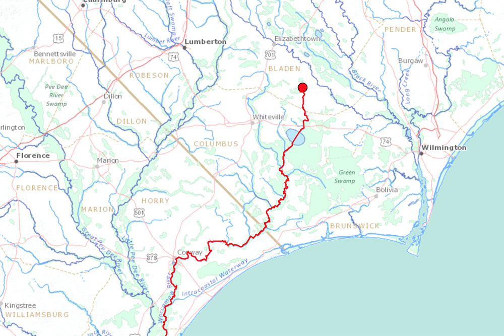
The National Weather Service (NWS) does not have permanent gauges where the Waccamaw River originates, north of Brunswick County.
Their first permanent gauge is located 90 miles downstream of the 121-mile river, according to United States Geological Survey (USGS), in Conway, South Carolina. The bulk of Conway’s flooding will be fed by creeks, swampland and the Waccamaw River as it makes its way through southwestern Brunswick County, where no NWS permanent gauges are located.
Conway’s gauge is reporting river levels at approximately 15 feet as of 9:15 p.m. Wednesday, four feet above the area’s flood stage and three feet below the highest recorded level. Because NWS has historical and daily data from this location, it has to work backward to be able to predict, with context, what could happen upstream from this location in the coming days.
Rick Neuherz, a NWS hydrologist, predicts the Waccamaw River at Conway will crest on Sunday afternoon at 20.4 feet, 2.5 feet higher than its record.
Just four miles south of the state line upstream from Conway in Longs, South Carolina, USGS’ gauge is already breaking records. This point of the river is over one foot over its highest recorded depth and is expected to crest at 24 feet by Sunday, Sept. 23. That’s nearly seven feet higher than the 1999 record, when Category 4 Hurricane Floyd made landfall on the east coast.
“We destroyed Floyd’s record with this one,” Neuherz said. “We’re doing that in a lot of places.”

Then there’s the USGS gauge at Freeland in Waccamaw, N.C., just north and upstream of where Brunswick County is currently urging people to evacuate. The river at Freeland is expected to crest at 23 feet, nearly four feet above Hurricane Floyd’s record, on Friday.
All of USGS’s upstream gauges were installed recently, or haven’t always been available to NWS, Neuherz said. This makes prediction modeling tricky, limiting NWS’ ability to offer both subjective and objective inferences from the data available.
“One of the issues with Freeland; One, is there’s nothing above it to help us, it’s the northernmost point in the system that we have,” Neuherz said.
According to USGS-reported data, the Waccamaw River has been rising at Freeland by about two feet every day. It’s already beating its Floyd-era record of 19.3 feet, with the latest reading on Wednesday at 9:30 p.m. over three feet higher.
“And two, they’ve only been measured up to 19 feet,” Neuherz said. “Part of that has been extrapolated, with some science, it’s not a guess.”
Relaying risk
Freeland and Longs’ USGS gauges haven’t lent enough data to offer nuanced, hour-by-hour predictions for this weekend, Neuherz said. With available gauges spread apart, Brunswick County officials have had to deduce an expected crest arrival date for people living in their floodplain.
In Conway, the river is expected to crest on Monday. Roughly halfway upstream at Longs, the river could crest Sunday. At Freeland, the river’s northernmost gauge, levels could crest by Friday.
To get people out in time safely, the county is anticipating the floodplain to reach its highest between Friday and Saturday, in line with NWS’ prediction for Freeland and Conway.
“We’re trying to think halfway between the two,” Brunswick County’s emergency services director, Brian Watts, said.
“What our assumption is and what the [National Weather Service’s] assumption is, the highest water will about the 22nd (Saturday).”
Back when Hurricane Floyd hit, southwestern Brunswick County looked a lot different.
“Not only was Floyd 20 years ago, [but] the development was much different, which makes floodplain much difference,” Watts said.

With new homes comes a new path for water around the homes, and ultimately, a new floodplain. Aside from the risk of rushing water alone, there’s a retired coal ash plant, a Superfund site and animal waste lagoons that could be soon be inundated by unprecedented flooding.
“When I talk about evacuations, evacuations are dangerous, it is dangerous to move people from one place to another,” Watts said.”If we’re telling you to evacuate, voluntarily or otherwise, we’ve weighed that risk and we think that’s the best thing for you to do.”
With a few days left to leave, officers are hoping people living in the floodplain will obey the county’s voluntary orders.
“We don’t haphazardously do that,” Watts said. “The risk of staying is more than the risk of evacuating. Bottom line.”
If an officer can’t make it to any of the thousands of doors needed to reach before this weekend, county officials hope people can reach out to their neighbors. Shelters are open for evacuees of this floodplain at West Brunswick High School in Shallotte and at South Brunswick Middle School in Boiling Spring Lakes. (More information on shelters can be found here.)
“It’s not a cause for panic or to be scared, it’s just simply a time to take the necessary measures to gather your belongings,” Sheriff Ingram said. “Things can be replaced. Lives can’t.”
View the Waccamaw River floodplain in its entirety, the area subject to voluntary evacuation as of Wednesday morning, below:
Waccamaw River floodplain, southern Brunswick County by Johanna Ferebee on Scribd
Send tips and comments to Johanna Ferebee at [email protected]

