An effort to develop New Hanover County’s first comprehensive plan is entering its second phase with a round of public meetings that continues tonight and will last through February.
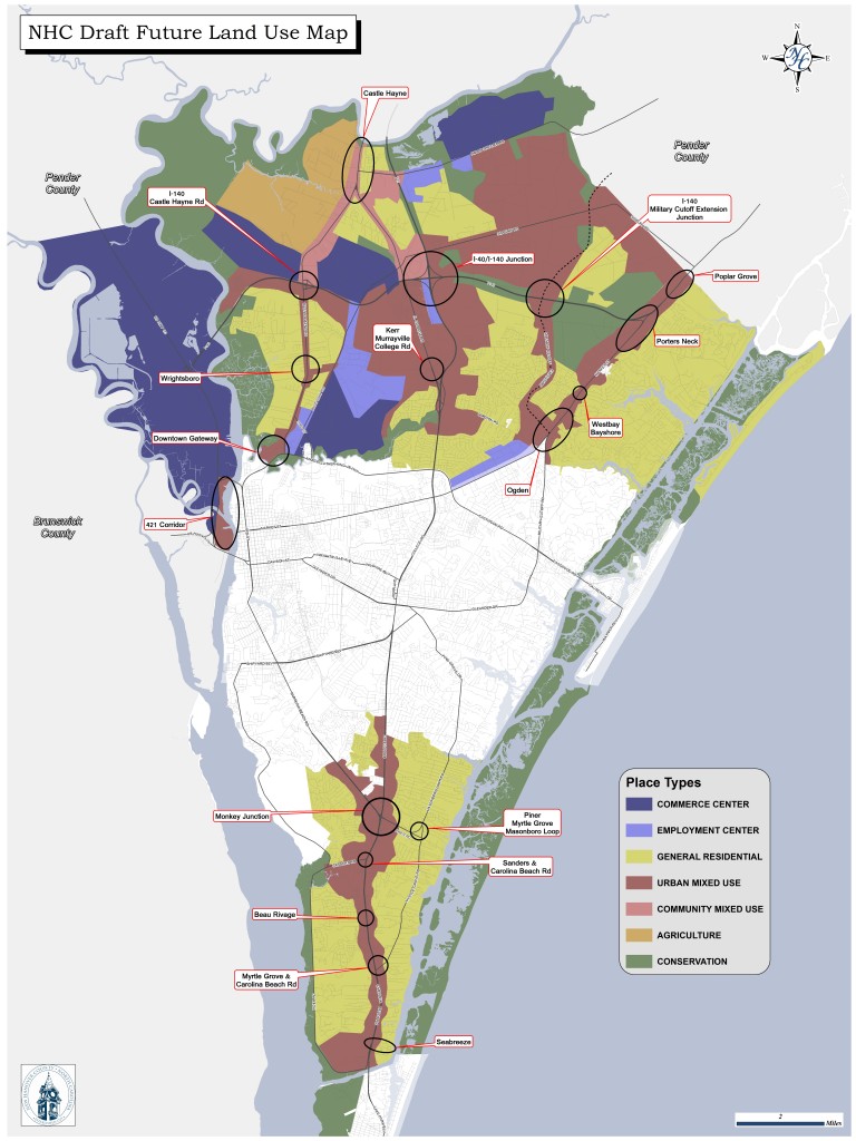
Called “Plan NHC,” the monthslong effort has compiled feedback from previous meetings and workgroup sessions to shape a proposed future land use map, which county planners are presenting to the public at the meetings.
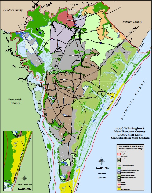
The map updates the county’s previous development blueprint, the CAMA Land Use Plan adopted in 2006. This newer map, which reflects different projections for development in the county—particularly the U.S. 421 corridor, which is set for more development with the addition of water and sewer utilities—will be part of the larger comprehensive plan that is intended to guide growth over the next 25 years.
Related story: County to develop first comprehensive plan; would help guide growth through 2040
Jennifer Rigby, project supervisor for Plan NHC, described this phase of the process as “where we take all of our goals and our visions for the community and put them on the ground—on a map.”
“It’s a really exciting map to look at when you think about where we’ll be in 25 years,” Rigby said. “We’re taking this map out to the community and asking for feedback: Did we get this right? Are there areas that you would like to see grow and develop differently? And if so, how?”
The meetings are being held at different locations throughout the county. Rigby said an initial meeting was held with area stakeholders and members of the development community, who she said responded positively and continue to provide feedback.
Rigby said the proposed map is considerably different from the 2006 CAMA Land Use Plan map (See below), particularly in regard to the northern part of the county, which is largely undeveloped and eyed for considerable growth. The industrial corridor along U.S. 421, which was previously identified as a mix of conservation land and areas in transition, is reflected on the new map as entirely commercial. Conservation land remains in areas on the other side of the Cape Fear River.
“There are a lot of areas in the northern part of our county that are undeveloped and are what we call greenfield development opportunities,” Rigby said, “so we’ve made some bold statements in those areas as far as how we think they could develop over the next 25 years, and we’d really like the community to provide feedback to us about whether this is what you would like.”
Rigby said the map also illustrates concepts of mixing land uses and integrating commercial development and community facilities into residential development. She said the county has worked with the City of Wilmington and neighboring Pender County to make sure the map is consistent with their plans.
Residents are encouraged to provide feedback on the map at the meetings, which are scheduled as follows:
- Jan. 29, 6-7:30 p.m., Bellamy Elementary School, 70 Sanders Road
- Feb. 3, 6-7:30 p.m., Ogden Elementary, 3637 Middle Sound Loop Road
- Feb. 10, 5-6:30 p.m., Murray Middle, 655 Halyburton Memorial Parkway
- Feb. 12, 6:30-7:30 p.m., Eaton Elementary, 6701 Gordon Road
- Feb. 17, 5-6:30 p.m., Myrtle Grove Middle, 901 Piner Road
- Feb. 23, 5-6:30 p.m., Wrightsboro Elementary, 2716 Castle Hayne Road
More information on the map and Plan NHC is available through the county’s website.
Related stories:
- New Hanover launches 18-month effort to develop first comprehensive plan
- Effort to develop first comprehensive plan continues in New Hanover
- Water and sewer extension expected to add to industrial corridor
Jonathan Spiers is a reporter for Port City Daily. He can be reached at (910) 772-6313 or [email protected]. On Twitter: @jrspiers