


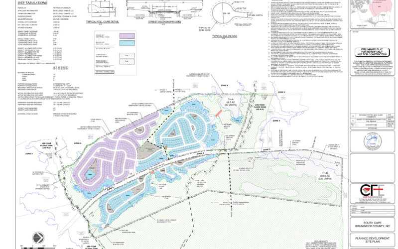
BRUNSWICK COUNTY — The Brunswick County Planning Board is slowly approaching the end of its final approval authority over developments, with 10 left to be decided upon as of Oct. 5 before county commissioners have final say, due to new legislation that passed in July. However, the three developments it approved this week will bring roughly 900 units to the county, with one development taking up the bulk: 800 homes in the South Cape planned development.
Only four planning board members were present on Oct. 12 and voted unanimously for all plans to move forward. It included Southport Cove for 27 single-family homes on 13.6 acres and the Carroll Tract near Winnabow for 18 single-family homes on 10.14 acres; though both projects received little pushback.
Half the meeting took up discussion about South Cape, located in Winnabow off River Road, abutting Mallory Creek and Brunswick Forest neighborhoods. The planned development passed despite planning staff, the Town of Leland, nearby neighborhood Brunswick Forest, and multiple residents calling on the board to reject the plans as is.
READ MORE: Brunswick commissioners ask state to drop traffic studies for special use permits
The most controversial point was flooding and the lack of interconnection between the proposed development and the neighboring Brunswick Forest Phase 4 community.
“I suggest you deny the project with or without a connective road,” Brunswick County resident Nicole Sullivan said during public comment.
The South Cape development aims to bring 519 single family homes and 310 townhomes on 348 acres near Winnabow for a total density of 2.38 dwelling units per acre.
The land has three separate zonings: rural low density residential, medium density residential and high density residential. South Cape’s proposed density falls below each of the zoning’s maximum allowance, including the lowest of 2.9 dwelling units per acre, making it permissible by-right.
There are three access roads, 1,658 off-street parking spaces with a minimum of two spaces per lot, 175.04 acres of open space and 11.27 acres of recreational space. Only 69.6 acres of open space is required and only 10.44 acres of recreational space is needed, so the developers exceeded what is necessary for approval.
Deputy planning director Marc Pages told the board “significant portions of the site” are in an AE flood zone, or high risk flood zone, including a large portion of the townhomes. According to agenda docs, the technical review committee met twice and noted “due to the amount of fill material the developer proposed,” they will need to receive a letter of map revision (LOMR) following project completion, but this only happens after a conditional letter (CLOMR) is granted. Overseen by FEMA, a CLOMR helps determine if a project can meet National Flood Insurance Programs, and ensures a project will minimize flood damage in the development and surrounding neighborhoods.
Site plans indicate the homes in these areas will need to be raised above the 100-year flood elevation and will be designed per FEMA standards.
The county’s stormwater ordinance says control measures need to factor in the 1-year, 10-year, 25-year, and 100-year 24-hour storms. The developer intends to include a stormwater management program to retain 1-, 10- and 100-year storm events, according to site plans.
Resident Travis Gillette opposed the development due to the property flooding, already an issue, he said. Gillette explained as a native of the area, he’s seen the undeveloped land “underwater” following heavy rain, which he said flows onto River Road, flooding the street.
Though he believed his automotive business would benefit from the property and a public thoroughfare running through it, Gillette led with his conscience.
“Greed shouldn’t come before common sense and making money should never come at the expense of public safety,” he argued.
The development is expected to yield 7,291 vehicle trips daily on weekdays, to be channeled through three access points. The development is accessible from River Road on the eastern side.
On the western side, there are three gated access points connecting to Brunswick Forest, intended for emergency use. Though, those who opposed the development wanted at least one gated point to be open.
Pages concurred an ungated pathway on the western side would be preferable to improve traffic by diverting South Cape travelers through Brunswick Forest to get to commercial areas by N.C. Highway 17, also known as Ocean Highway SE. However, some board members did not agree.
Robert Needham was the first to speak in opposition to staff’s request for an access road.
“Some of what I’m seeing here, I’ve coined the term ‘regulatory extortion,’” Needham said, noting vehicles would still find their way onto River Road.
He didn’t want staff or the planning board to make unwarranted demands as a condition for approval.
“Where somebody wants something and the powers that be say not unless you do this for me,” Needham said. “And I’m not saying that’s what this is — what I’m saying is, it’s close enough it makes me uneasy.”
Needham was joined by planning board alternate Cecelia Herman, who agreed it was unnecessary and would have adverse impacts. She said the South Cape community would be inundated with traffic from N.C. Highway 133, i.e. River Road, which would defeat the purpose of a private neighborhood.
“I think that there’ll be a lot of traffic cutting through,” Herman said. “Then he’s building a development that has all private roads — and he’s maintaining all these private roads — and half the world’s gonna cut through them to get to the other side.”
Brunswick Forest developer Chad McEwen, who used to work as deputy city manager for the City of Wilmington, did not agree with the site plan as presented and leaned into staff’s recommendation. McEwen is the director of development for the Funston Company, which develops Brunswick Forest and wanted ungated access between the two communities as well.
“A collector street connection from N.C. 133 through the South Cape development is an indisputable example of sound planning and responsible growth management,” McEwen said since it will divert traffic off of busy River Road.
The two lane, roughly 47-mile road, between Southport and Leland, has over 6,000 travelers on it daily, according to NCDOT.
The South Cape developer was represented on Monday by Wilmington attorney Colin Tarrant who, after introducing the other development team members, suggested staff was attempting to infringe on his client’s property rights.
“Something stinks. Something doesn’t pass the smell test here,” Tarrant said. “It’s a private development, it’s a private property, it’s a private road. Why is this developer being told he’s gotta take his private road and turn it into a collector street?”
Because a collector street is connected to a main highway, it would have more traffic and therefore need to be larger. According to North Carolina Department of Transportation standards, collector roads must be 34 feet wide and local roads must be 26 feet.
It also has to have more stormwater management.
In addition to Tarrant, Elaine Jordan with the Coastal Companies and part of the South Cape development team thought it was unfair for the developer to carry the cost burden of road maintenance when it was being used by people outside the property.
According to the traffic impact analysis provided in the application, 65% of Brunswick Forest would use the road should it open, amounting to roughly 6,700 vehicles per day. The increased traffic load would require more maintenance and roadway preservation efforts that Tarrant said comes from the developer.
Leland Planning and Inspections Director Ben Andrea countered this point; he said the town was already open and willing to maintain the road, not yet named, to connect Brunswick Forest and South Cape. The Leland fire chief, Town Manager David Hollis and Andrea sent a letter to the planning board with this in mind, requesting the development not be gated. The South Cape community would be within Leland’s fire district, so it would impact the town’s fire services, too.
Jordan said the “collector street” would take away developable land because it’s wider. With these new conditions, she reasoned it would be more difficult for the homes closest to the entry point to back into and out of their driveways safely. Thus, the developer would be forced to remove them from the site plans.
“I’m sorry, this is a taking,” she said. “The South Cape developer would bear an extravagant cost to construct a road to the heavy-duty collector road standards. The Brunswick Forest developer is trying to add value to his property while taking it from us.”
Caleb Rash, an attorney representing McEwen, however, said the access point would make the development more sustainable by allowing the collector street to “function in an interdependent manner.” This would mean traffic distribution by introducing multiple routes and improved vehicle access. The collector street, he said, was first brought up in the spring TRC meeting.
“The applicant could do something about it and is simply refusing to,” Rash said, suggesting the developers go back to the drawing board. “This board really needs to send a message that interconnectivity is a real fundamental principle for Brunswick County planning.”
Rash cited Article 6 of the county UDO which states that an interconnected street system — so in this case, including a collector street — promotes public safety by providing additional access points to an evacuation route and additional means of exiting. It would also allow for easier travel for emergency vehicles.
However, staff noted the baseline requirement for South Cape is the development must have three access points because it is over 120 dwelling units. According to the UDO and Assistant County Attorney Ryan King, the planning board can choose whether they have an extra access point. If the planning board does not require the gate to be open, it does not have to be.
But Rash believed allowing access between Brunswick Forest Phase 4 and River Road was the “right way” to develop the land. He suggested the board either deny the proposal as is or demand they open the gate.
“I’ll close by saying I do agree with Mr. Tarrant that something stinks but if you got everyone on one side and one person on the other, it’s probably the site plan itself that stinks,” Rash said.
Tarrant argued interconnectivity isn’t required under the county UDO, and thus the collector road couldn’t be a requirement for approval. He added Brunswick Forest Phase 4 also had alternative options developers could explore.
“I think if they really put their minds to it, they might be able to design something that could allow them some access to 133 that doesn’t require forcing a private property owner to utilize his road in a fashion that best suits Brunswick Forest and their developers,” he said. “They all have a stake in making sure that Brunswick Forest is successful. And how can Brunswick Forest be successful? By having Brunswick County take on all of the liability of making this decision.”
Sullivan echoed his statements, pointing to when River Road collapsed in on itself following Potential Tropical Cyclone 8 in 2024. It was closed by the NCDOT for almost a year, with traffic diverted to N.C. Highway 87 and U.S. Route 17 when traveling from Belville, Leland and Wilmington to Southport.
Ultimately, the planning board sided with the South Cape developer. Herman made the motion to approve.
“There is no reason to have a connector road through the development,” she said.
The development was approved unanimously.
Have tips or suggestions for Emily Sawaked? Email [email protected]
At Port City Daily, we aim to keep locals informed on top-of-mind news facing the tri-county region. To support our work and help us reach more people in 2026, please, consider helping one of two ways: Subscribe hereor make a one-time contribution here.
We appreciate your ongoing support.
