
BRUNSWICK COUNTY — In a local coastal county, about 1,900 residential units are up for review next week, including a previously denied development that has made slight changes to plans to address public and board concerns.
On Monday, Feb. 9, the Brunswick County Planning Board will be reviewing four planned developments, including one modified site plan. A planned development allows for a mixture of uses to be built as one project. For example, it allows a combination of commercial and residential uses in one site plan. Planned development also allows for units to be constructed more closely together in a clustering effect, reducing the need for additional infrastructure or easements.
READ MORE: 292-home development planned in northern New Hanover resurfaces after 3-year lull
Among proposals coming before the board on Feb. 9, Cherrytree Tract is up for another round of review, after being denied in September 2025 due to flooding and traffic issues. Also on the docket is the 88.8 acre Mirasol Residential near Southport, the LaDane Gardens on 408.6 acres near Ocean Isle Beach, and Long Beach Road Residential near Southport.
Public hearings for each development will be open for comment as well; sign up is at the door and allots 3 minutes per person.
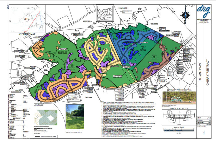
Cherrytree Tract
The largest of the four projects, Cherrytree Tract is back after receiving unanimous denial from the planning board.
Board members voted against it due to concerns of schools being at capacity, traffic, and, most nominally, flooding.
Proposed by Leland Estates to build 1,000 single-family units on 741.09 acres, the unit count of the development hasn’t changed. Six hundred of the homes will be unattached single-family and 400 will be attached single-family homes.
However, since the last meeting, the developers have altered the site plans slightly:
- Designating 1/2 acre for EMS vehicles to park and wait
- Moved the proposed pond away from the cemetery for a larger buffer, fencing and landscaping
- Added 3 community parks to the residential pods
- Increased the active open space from 16 acres to 35
- Added an access point to a nearby parcel for interconnectivity.
Planning board members’ main concerns in September included the fact that the Floodplain Administrator recommended denial based on the sites presented as is, which did not show flood zone boundaries and non-encroachment lines on its mapped outline. In addition, members requested developers amend the plans regarding the property’s proximity to the Tharp cemetery.
More than 10 residents spoke against Cherrytree Tract in the fall. While many reiterated concerns of flooding and traffic, others were concerned about wildlife conservation, the preservation and integrity of the local cemetery adjacent to the development. They also expressed worry over whether emergency services personnel would have adequate access to the area.
The property is zoned Rural Residential, limiting unit density to 2.9 dwelling units per acre, but Cherrytree falls under at 1.35 dwelling units per acre.
The project splits the development areas into “pods” — four are residential, and there is a separate commercial pod to the northwest of the properties and residential units. The commercial development will be 25 acres, though no official plans have been put forth for what businesses will operate there. Usually permitted in planned developments, however, are small-scale retail and service businesses and professional offices.
According to the project’s traffic impact analysis, the development will generate an additional 8,294 daily trips, 602 new trips during the peak morning hour, and 791 new trips during the evening peak on a typical weekday at Bell Swamp Road, south of Cherrytree Road. Traffic patterns suggest current daily trips equate to about 2,000 on average.
If approved, the developers will have a vested right to the land for the next three years to develop it.
Mirasol Planned Development
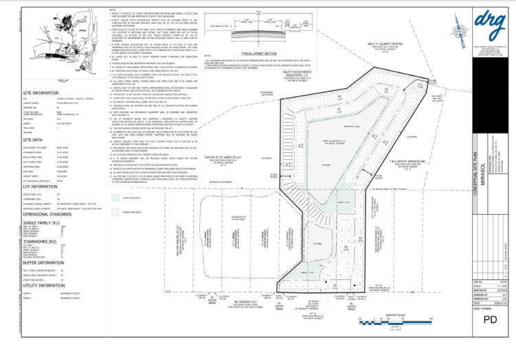
A new development by Jones Holdings — known primarily for its sand mine, the Mirasol Family Mine, located a “quarter-mile west and across Highway 211 from the St. James entrance” — Mirasol is planned to consist of 195 single-family units and 145 townhomes on about 88.8 acres on Southport-Supply Road. The development was supposed to be discussed at the October planning board meeting, but it was pulled from the agenda.
The location is zoned Commercial Low Density, which allows for 13.6 dwelling units per acre, though developers only plan to build 3.83 dwelling units per acre.
The site requires two dedicated right turn lanes, with deceleration and taper lanes and lengths on NC 211 in order to accommodate two driveways for the entry and exit points to the property. The development will generate 2,806 daily trips, 202 during the morning peak hour, and 265 trips during the evening peak hour on Southport-Supply Road, NC 906 and St. James Drive. Traffic in these areas currently range from around 15,000 to nearly 20,000 daily trips.
As a part of the approval criteria for the project, there will be a minimum of two driveway parking spaces per lot, with the remainder as off-street parking.
The site plan also includes 42.98 acres of dedicated open space — no wetlands — and 9.53 acres of recreational use space. The stormwater retention ponds are also designed for a 100-year storm event and will take up 22.52 acres of land.
Water and utilities will be covered by the county.
LaDane Gardens
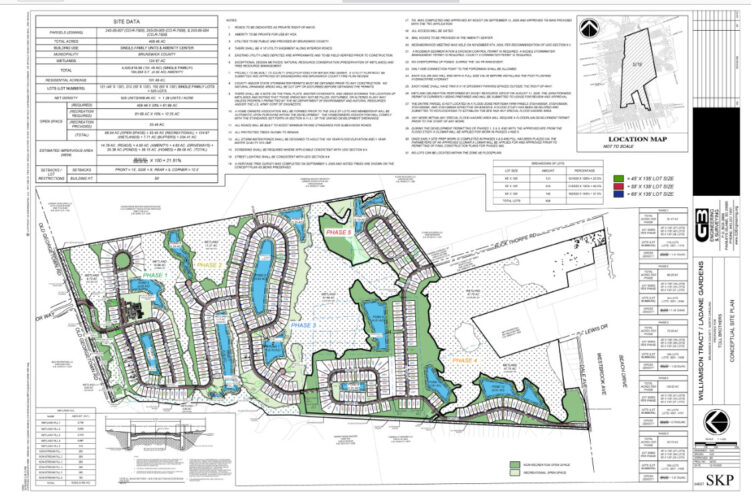
Owned by Grand Strand National LLC and LaDane Williamson Family Legacy Trust, LaDane Gardens, if approved, will be located along Old Georgetown Road near Ocean Isle Beach. The LW Family Trust owns property across Ocean Isle, while the Williamson family is known for its philanthropy work in Brunswick County.
The project is on 408.46 acres, to consist of 525 single-family homes, with two driveway parking spaces, for an overall density of 1.29 dwelling units per acre. Zoned Medium Density Residential, the property allows for a maximum density of 5.3 dwelling units per acre, with water and sewer.
There are five phases for the project’s construction, designed around 124.67 acres of wetlands on the property. The first phase will cover 81.47 acres at 115 lots, with a second build-out consisting of 94 lots on 66.25 acres. The third 78.39 acres will include 109 lots, the fourth 128.63 acres will house 101 lots, and the last phase will be the remaining 53.72 acres of 106 lots.
The project also includes 234.41 acres of dedicated open space and a proposal for 33.49 acres of recreation space, with walking trails, a dozen ponds, and small parks.
Due to the surrounding wetlands, the property is also in a flood zone. To ensure compliance with the Federal Emergency Management Agency, floodplains regulations, and county ordinance, the developers will need to establish a Base Flood Elevation to combat flooding from 100-year storm events, which would bring 27.1 to 27.35 feet of water. All buildings within the floodplain will need to be elevated 2 feet above that flood level.
A traffic impact analysis was also conducted for the development; the project would generate 4,639 daily trips, including 337 trips during the morning peak and 472 trips during the afternoon/evening peak on Old Georgetown Road, Dartmoor Way, and Seaside Road. Along Old Georgetown Road and Seaside Road, traffic numbers consist of between 10,000 and 15,000 daily trips.
The TIA recommended inclusion of a 100-foot eastbound right turn lane and a 125-foot westbound left turn lane on Old Georgetown Road. In addition, the analysis suggested one ingress and two egress lanes would be needed for the site access point at Old Georgetown Road and Dartmoor Way.
All access points to the property will be gated and the roads will act as private rights-of-way.
Long Beach Road Residential Planned Development Modification
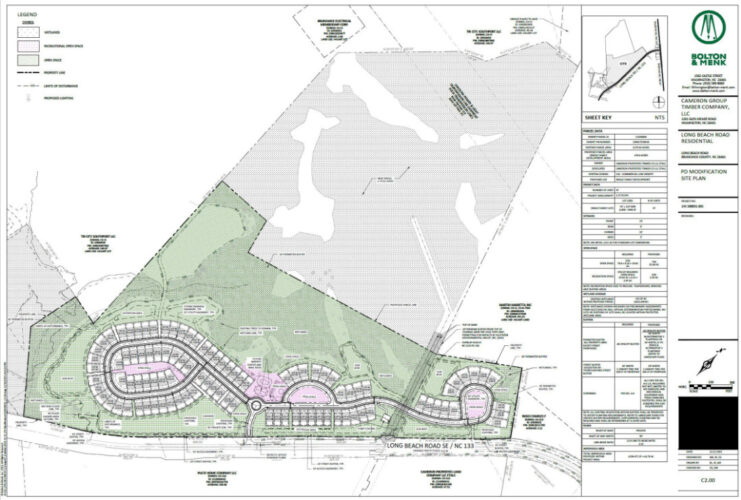
Owned by Cameron Group Timber LLC and applied for by Bolton and Menk, the first site plan for Long Beach Road Residential was previously approved in May 2025. Founders of Cameron Group Timber LLC, with relation to Cameron Management, most notably were behind the Bayshore development and Figure 8 Island.
Original plans included 49 single-family units and 84 townhomes on 152.77 acres, for a density of 0.87 dwelling units per acre. Zoned Commercial Low Density, the maximum density permitted is 13.6 dwelling units per acre.
The new plan nixes half of the developable land from the project. It no longer includes 74.02 acres and 36 units from the site plans, and replaces all the townhomes with single-family units. The plan proposes 97 single-family units on approximately 78.6 acres, creating a density of 1.23 dwelling units per acre.
Port City Daily reached out to the applicant to inquire about why the property owner chose to reduce the planned development but was unable to receive a response.
The developers are proposing 55.88 acres of open space and the minimum 2.95 acres of recreation space. There will be an amenity center for residents, as well as a mail kiosk. Stormwater ponds were also designed to withstand 100-year storm events.
The development will generate approximately 981 daily trips — peak morning and afternoon hours trips were not included in the report along NC 133, which currently gets over 20,000 daily trips.
Also required are two roadway improvements: a southbound right turn lane and a northbound left turn lane each with 50 feet of storage or space for vehicles in order to accommodate the increase in traffic.
Water and utilities will be provided by the county.
Have tips or suggestions for Emily Sawaked? Email emily@localdailymedia.com
At Port City Daily, we aim to keep locals informed on top-of-mind news facing the tri-county region. To support our work and help us reach more people in 2026, please, consider helping one of two ways: Subscribe here or make a one-time contribution here.
We appreciate your ongoing support.