
SOUTHEASTERN N.C. — It’s take two of a winter weather storm approaching the region after last week’s ice event affected mostly inland areas of the state. This weekend there is a 100% chance of snow in the cards for southeastern coastal communities, which the National Weather Service in Wilmington is calling “historic.”
“Some areas haven’t seen this amount of accumulating snow in over 30 years,” NWS Wilmington noted on socials Thursday.
ALSO: Could weekend cold front bring snow? Maybe.
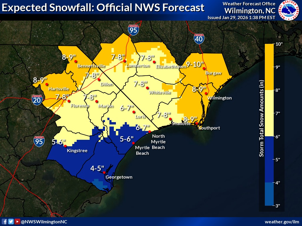
According to the agency, accumulation amounts are not firm but it expects anywhere from 7 to 10 inches of snow to fall, with accumulation of 8 to 9 inches from Southport to Wilmington and 9 to 10 inches further north in Burgaw. Should it lessen, on the low end NWS would anticipate at least 2 to 4 inches.
This means many of NWS’s 14 counties are under a winter storm watch, from Georgetown County in South Carolina up to Pender County in North Carolina. It includes both Brunswick and New Hanover counties.
The last time Wilmington experienced snow to this degree was in December of 1989, when 15 inches blanketed the region near Christmas. Last year in January snow fell between 3 and 5 inches.
NWS noted this latest stretch of cold weather, 13 consecutive days this year, is the most below-freezing temperatures regionwide since 2011. But the last time wind chill temperatures dipped close to 0 degrees at ILM — anticipated this weekend — it was 1994 and reached -1 degrees.
A low pressure system — dubbed Winter Storm Gianna by The Weather Channel — is approaching with Arctic cold air bringing frigid temperatures, dropping into single digits with wind chills on Friday. It could elicit blizzard-like conditions in some parts of eastern Carolina.
Late Friday evening, a wintry mix of precipitation may begin and continue through the weekend, but it will worsen Saturday evening. Snow is expected to begin heavily falling overnight into Sunday and will lead to hazardous, slippery driving conditions and dangerous marine conditions. Wind also will pick up potentially with 40 mile-per-hour gusts; thus, NWS expects visibility may drop below a quarter-mile due to falling and blowing snow causing a “whiteout” once the storm is in full force.
More so, because the cold temperatures are sticking around, commutes into Monday and Tuesday could also be compromised.
Preparations ahead of the storm
Governor Josh Stein held a press conference Thursday, noting unlike last week’s ice event mostly impacting the mountains, Piedmont and Triangle, this weekend’s event is approaching from the east, not the west. The Outer Banks could receive more than a foot of the white stuff, with inland regions, such as Raleigh, also feeling effects.
Stein issued another state of emergency in case FEMA’s help is needed and to activate response from other agencies. The declaration allows, for instance, the National Guard to help deploy supplies or work with the State Highway Patrol to remove vehicles and trucks stuck on roadways so NCDOT can clear roads.
“We hope power outages are a smaller part of the story,” Stein said Thursday, referring to last weekend’s ice storm, which Duke Energy reportedly restored power to 150,000 properties statewide.
Some crew members of the North Carolina Department of Transportation have worked 100 hours in the last week clearing ice. Stein commended them, saying as far as he knew their work paid off as he was unaware of traffic fatalities so far due to the weather.
The governor appeared at a brining facility Thursday, advising people impacted by the weekend’s snowfall to avoid driving starting Friday, when temperatures drop and precipitation could begin. There is a 40% chance of a wintry mix Friday, with significant snowfall increasing to 100% by Saturday evening.
“These guys need to be on the road plowing,” the governor said of NCDOT. “So if you can stay off the roads, you make their jobs a whole lot easier and safer.”
NCDOT normally clears major thoroughfares before tackling smaller streets and corridors. Crews confirmed to Stein, there was enough salt and sand to treat roads ahead of the storm despite last week’s weather event having them working in full-force.
The transportation department tries to brine roadways 48 hours ahead of impact. Once precipitation begins to fall, it brings out plows.
“Unfortunately, we’re gonna be running right up till tomorrow afternoon getting done with brine,” according to Division 3 Maintenance Engineer Battle Whitley.
Locally, NCDOT held a press conference Thursday as well. Whitley said crews have 4,000 tons of salt, 50 trucks with plows and spreaders, and 11 contract motor graders. The latter consists of machines that do high-speed, long-distance road-clearing, good for highways and large areas. The department has reached out to contractors to increase the number of motor graders on hand.
Crews are also prepared to get equipment and resources, such as more sand, from other agency divisions if possible.
“If there’s somebody who’s got some lesser impact, and they get done quicker, then they’ll ship,” Whitley explained.
Priority areas local crews will focus on include I-140, I-40, U.S. Highway 17, access roads to the hospitals, four-lane roads and other major corridors. They also will brine bridges, which freeze over first.
“Stay home, stay put if you can,” Whitley suggested.
City of Wilmington announced its crews have been brining city-owned roadways and the Wilmington International Airport has activated its snow and ice plan, with removal crews and equipment ready to tackle potential winter weather. ILM noted individual airlines will be behind decisions regarding flight schedules and instructs travelers to check all statuses ahead of travel, before heading to the airport.
In Kure Beach, town officials have begun deploying temporary generators at lift stations and ensuring stormwater drains remain clear, while emergency services are preparing staffing levels.
The New Hanover County Schools has released a statement that it is prepared to go to remote learning on Monday and Tuesday if needed.
Locals should prepare emergency kits now and begin weatherizing homes and cars as need be; see a list of suggestions here.
“I fully anticipate families to be impacted a few days as cold temperatures could make the snow stick around,” Stein said. “So use this as an opportunity to remind yourself how to sled.”
At Port City Daily, we aim to keep locals informed on top-of-mind news facing the tri-county region. To support our work and help us reach more people in 2026, please, consider helping one of two ways: Subscribe here or make a one-time contribution here.
We appreciate your ongoing support.