


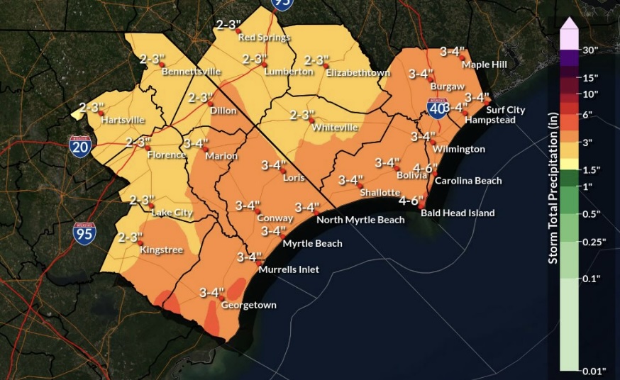
WILMINGTON — Another Isaias is turning out to be a hurricane five years after one with the same name came ashore in coastal southeastern North Carolina. Only this time around the Category 3 storm is the first of the Atlantic’s 2026 season and will make landfall in the Gulf Coast on Friday evening. However, Hurricane Isaias’ aftereffects may be felt locally this weekend, with heavy rainfall, flooding and winds that could cause some power outages as the storm moves across the states.
Local events are canceling or postponing due to impacts and a flood watch was issued by the National Weather Service in Wilmington on Friday.
Hurricane Isaias is anticipated to bring between 2 to 6 inches or rain across the Cape Fear region by Sunday. Isolated higher amounts could be up to 8 inches depending on the intensity of bands reaching varied areas. A flood watch went into effect Friday around 1:20 p.m. for inland and coastal regions of Brunswick, New Hanover and Pender counties, and continues through Sunday morning.
The storm’s aftermath will reach the area Saturday, with some thunderstorms anticipated before 3 p.m. though the heaviest rainfall will happen late Saturday into Sunday, according to the weather service. The weather service anticipates the heaviest remnants of Isaias will be west of southeastern North Carolina and northeast of South Carolina.
Rainfall could bring flash-flooding, which may cause road closures. Motorists should exercise caution and avoid driving through flood waters.
Winds also may reach anywhere from 30 to 60 miles per hour and isolated tornadoes may be possible, with the potential for felled trees and power lines.
Minor flooding is possible with high tides on Saturday and Sunday and in low-lying areas, including area beaches and the Cape Fear River in downtown Wilmington. There is a moderate-to-high risk for dangerous surf conditions, including strong, life-threatening rip currents. The surf advisory includes 6-foot breaking waves.
Area residents should take precautions to secure outdoor items and prepare emergency kits as necessary.
Local events are canceling and postponing due to the deterioration of weekend weather conditions; check back for updates to the list:
Art in the Arboretum — Postponed from Oct. 10-11 to Saturday, Oct. 31, and Sunday, Nov. 1. Learn more about the event here.
Belville’s Founders Day/America 250 Celebration: The Town of Belville is canceling its Saturday event. Though the town doesn’t expect direct heavy impacts, the outer rain bands are projected to affect some southern portions of Brunswick County more and provide a significant amount of rain and wind. There is no rain date for the event, but it will return in 2027 as Belville celebrates its 50th birthday.
Broomtail Brewing Sunday Funday Vendor Market — Canceled for Oct. 11.
Fire in the Pines Festival — The New Hanover County festival held at Halyburton Park celebrates controlled burns for the ecosystem but has been canceled for Saturday, Oct. 10. A rain date is being considered; follow the festival here.
Fall Homestead Festival — Barn Bird will not host its Saturday and Sunday, Oct. 10-11, events; there is no rain date.
Nest County Fair — The Nest Realty event was scheduled for Poplar Grove Plantation but is no longer happening.
Pumpkins and Purrs — The cat adoption event to be held at 1540 S. 2nd St. is postponed.
Push Up for Parkinsons — Scheduled for Oct. 10, the fundraiser at Sunset Beach Town Park has been moved to Oct. 25; learn more here.
Riverfront Famers’ Market — Normally takes place downtown every Saturday but Oct. 11 won’t happen; the market will return Oct. 17.
Touch A Truck — Junior League of Wilmington’s event is being postponed to Nov. 15 at The Pointe at Barclay; learn more here.
At Port City Daily, we aim to keep locals informed on top-of-mind news facing the tri-county region. To support our work and help us reach more people in 2026, please, consider helping one of two ways: Subscribe here or make a one-time contribution here.
We appreciate your ongoing support.
